California Earthquake Authority Publishes Natural Catastrophe Resiliency Report
California Earthquake Authority Publishes Natural Catastrophe Resiliency Report
April 7, 2026 – The California Earthquake Authority, in their capacity as Administrator of the California Wildfire Fund, delivered their report, Enhancing California’s Resiliency to Natural Catastrophes as required under SB 254. The legislation required the Authority to evaluate policy options to reduce damages to life and property, accelerate post-disaster recovery, and equitably allocate the costs of natural catastrophes in California, including catastrophic wildfires. The report identifies three overarching Policy Pathways, each of which are supported by multiple strategies and actions.
-
- Commit to community wildfire risk reduction: Focuses on greater state coordination, guidance, and resources for local governments; increased capacity at the community level, developing shared data and information to support local mitigation planning, and setting some new requirements that further support existing priorities related to electric utility safety, accountability, and reporting.
- Equitably allocate catastrophe burdens: Addresses existing cost-sharing structures that are not fit-for-purpose to manage the extreme wildfires, including issues such as investor-owned utilities being burdened with inverse condemnation, disproportionate contributions to wildfire mitigation from residential ratepayers, access to property insurance, and delivery of post-disaster compensation payments.
- State roles for addressing catastrophe resiliency: Focuses on financing strategies to respond to catastrophic events as well as new public and private financing strategies to facilitate wildfire mitigation, such as home and community hardening, defensible space, and vegetation management.
- Commit to community wildfire risk reduction: Focuses on greater state coordination, guidance, and resources for local governments; increased capacity at the community level, developing shared data and information to support local mitigation planning, and setting some new requirements that further support existing priorities related to electric utility safety, accountability, and reporting.

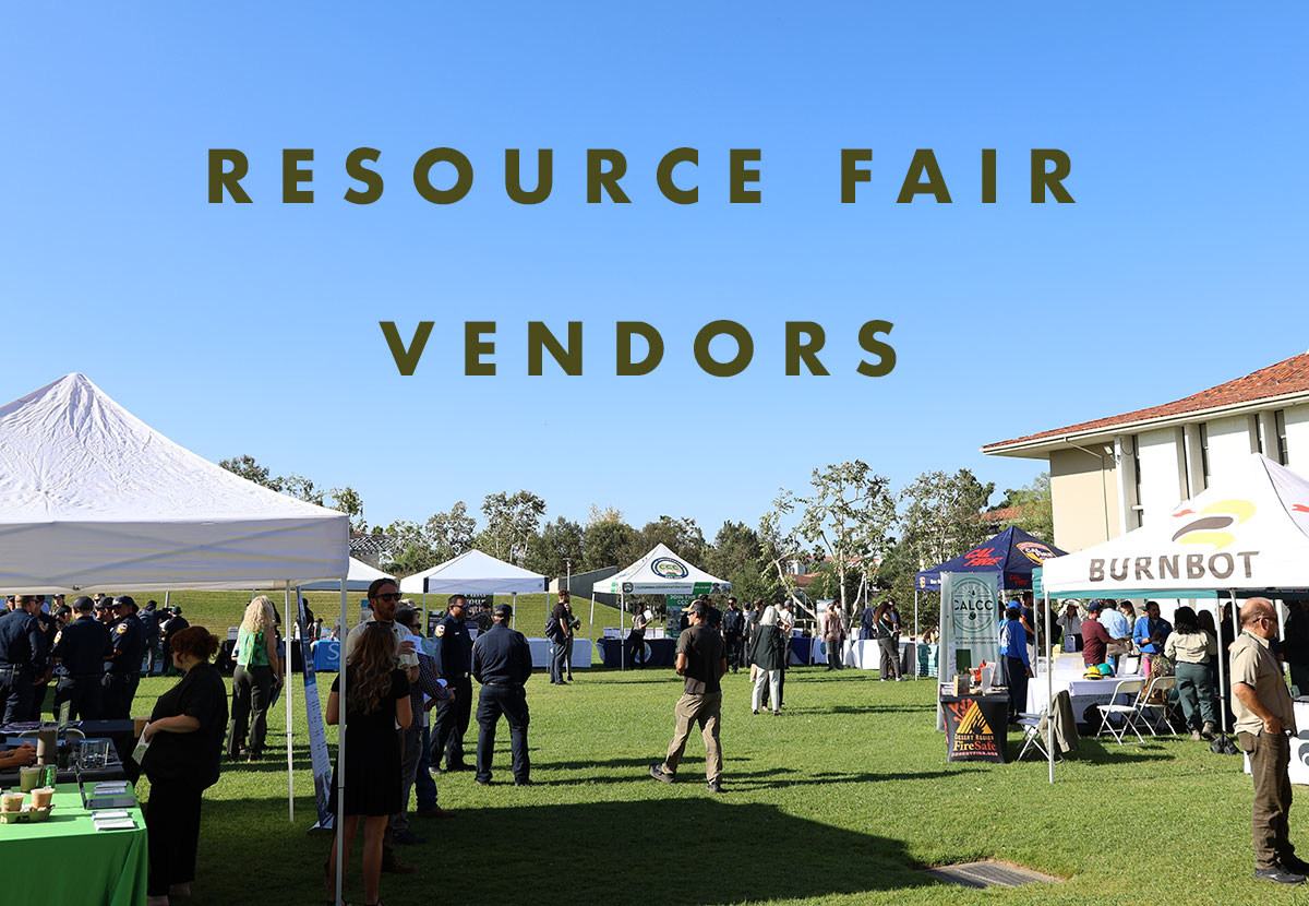
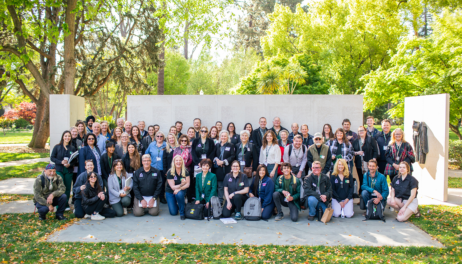
Sierra Nevada Resource Fair Vendors
Over 30 vendors participated in the Resource Fair!
CLICK THE NAMES BELOW TO FIND OUT MORE
-
American Forests
-
Ascent
-
BENEN
-
Blue Forest
-
Bureau of Land Management
-
BurnBot, Inc.
-
California Dept of Water Resources
-
California Fire Safe Council
-
CalTrans – Office of Natural Resource Managment
-
Dudek
-
Forest Educators Inc.
-
Greater Valley Conservation Corps
-
Hana Resources
-
Mammoth Lakes Trails and Public Access
-
RC Mowers
-
Sierra Ecosystem Associates
-
Sierra ForestWorks
-
Sierra Mountain Construction Inc.
-
Sierra Nevada Conservancy
-
Swedish-American Chamber of Commerce – Forest Innovation Summit
-
Tribal EcoRestoration Alliance
-
UC Cooperative Extension Forest Stewardship Program
-
USDA CA Climate Hub
-
Watershed Research and Training Center
-
Wildfire Solutions Coalition
-
Yosemite Rivers Alliance
California Fast Tracks 300 Wildfire Projects in 300 Days
FOR IMMEDIATE RELEASE
March 20, 2026
California Fast Tracks 300 Wildfire Projects in 300 Days
Progress Highlighted at Wildfire Task Force Regional Meeting
What you need to know: During the Wildfire and Forest Resilience Task Force’s Sierra Nevada Regional meeting, California announced it has fast-tracked over 300 critical fuels reduction projects across the state in just over 300 days— enabling a broad cross-section of communities, local fire safe councils, tribes, and organizations to move faster than ever before. Additionally, local partners showcased projects that are strengthening wildfire resilience in the Central Sierra and the Task Force previewed its 2026 Wildfire and Landscape Resilience Action Plan.
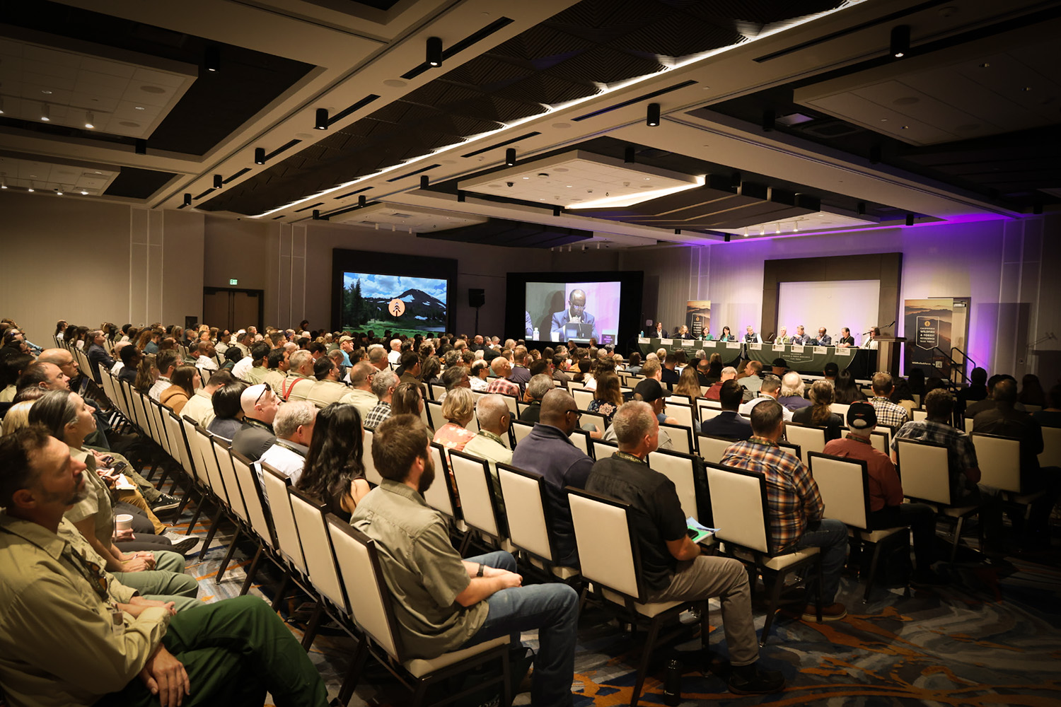
Jamestown, California – On March 19, Mountain Counties Water Resources Association and Sierra Nevada Conservancy hosted the California Wildfire and Forest Resilience Task Force’s Sierra Nevada Regional Meeting at the Chicken Ranch Casino Resort in Tuolumne County. During the meeting, the Task Force shared an update on California’s progress to streamline permitting for wildfire projects, which has enabled a wide range of agencies, tribes, and organizations to move faster than ever before to deliver real results. Three panels of local leaders provided examples of how partners in the Central Sierra are working across land ownerships, developing a robust workforce, and utilizing innovative funding strategies to bring wildfire projects to scale. Lastly, the Task Force provided updates on the development of its 2026 Wildfire and Landscape Resilience Action Plan.
“Across California, Task Force partners are proving that when we remove barriers and work together, wildfire resilience can happen faster and at the scale our communities and landscapes need,” said Task Force Director Patrick Wright. “From the Sierra Nevada and beyond, agencies, tribes, local leaders, and innovators are showing how collaboration, workforce development, and new funding approaches can turn momentum into real progress on-the-ground to protect communities and restore landscapes.”
CALIFORNIA FAST-TRACKS 300 PROJECTS ACROSS LAND OWNERSHIPS IN 300 DAYS
Following Governor Newsom’s emergency proclamation on wildfire, State agencies including the California Natural Resources Agency (CNRA) and California Environmental Protection Agency (CalEPA), have coordinated to cut red tape and fast-track critical wildfire safety projects across the state, all while maintaining vital environmental safeguards. Through this streamlined process, projects are now being approved in as little as 30 days, saving a year or more of review and red tape for more complicated projects.
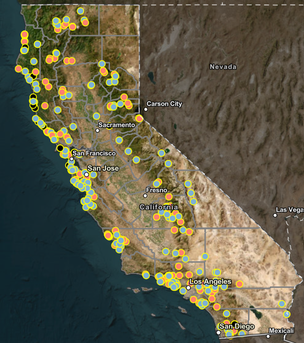
Thanks to these efforts, over 300 projects across nearly 57,000 acres have been approved in all reaches of the state. This streamlining process has been a game changer for a wide range of state and federal agencies, tribes, resource conservation districts, firesafe councils, private landowners and more, to get critical work done faster. Fast-tracked projects are protecting vulnerable communities, improving defensible space, creating evacuation routes, and restoring ecosystems. We are already seeing a major impact on the ground with notable projects including:
- a collaborative 600+ acre fuels reduction project protecting communities in the Los Angeles area near the Palisades footprint led by the Mountains Recreation and Conservation Authority;
- the 450 acre Prosper Ridge Community Wildfire Resilience Project that is incorporating cultural burning and prescribed fire for community protection in Humboldt County;
- the nearly 3, 000-acre Scott Valley/Callahan Fuels Reduction Project to restore ecosystem health and protect vulnerable rural communities in Siskiyou County; and
- a project offering defensible space assistance for seniors and at-needs residents in Tuolumne County.
Thanks to the Governor’s extension of the emergency proclamation, project streamlining applications are being accepted through May 1, 2026. Visit the Task Force’s Project Streamlining webpage to learn more, view all approved projects and submit your application.
SHOWCASING LOCAL EFFORTS IN THE CENTRAL SIERRA
Unprecedented Collaboration Across Ownerships: The Sierra Nevada Regional Meeting highlighted how partners are coordinating work across federal, state, tribal, local, and private lands to achieve meaningful landscape-scale impact. A prime example showcased at the meeting is the Social and Ecological Resilience Across the Landscape (SERAL) project, a landmark collaboration that is restoring forest health and reducing wildfire risk across tens of thousands of acres by coordinating treatments across public and private lands—demonstrating how large-scale, science-based forest management can strengthen both ecological resilience and local economies. Another example of how the Central Sierra is overcoming challenges experienced in other parts of the state is the opening of Tuolumne BioEnergy, a new biomass facility in Sonora that will help convert forest waste from fuels reduction projects into renewable energy while supporting local forest management and reducing the amount of material left to burn in wildfires.
Building a Workforce to Implement Projects at Scale: Local leaders emphasized that scaling wildfire resilience work requires a skilled workforce. The Tuolumne Band of Me-Wuk’s Tuolumne Rancheria Fire Department shared how they are building tribal leadership in fuels reduction, cultural burning, and community protection. The wildfire technology company BurnBot shared how new technologies are helping accelerate work on-the-ground and how its equipment can help land managers conduct prescribed fire more efficiently and safely. Local businesses are also playing an important role in the Central Sierra. Companies such as Heartwood Biomass are creating jobs while supporting forest health by processing and utilizing material removed during fuels reduction projects. Together, these efforts are helping grow a stewardship workforce capable of implementing wildfire resilience work at the scale California needs.
Innovative Strategies to Fund Wildfire Resilience: Meeting panelists discussed how emerging approaches to financing wildfire mitigation are aligning economic incentives with risk reduction through innovative insurance and financing models that reward communities and property owners that invest in wildfire resilience. One example is RockRose Risk, which is working with communities to provide insurance discounts for homeowners who complete wildfire mitigation work. A pilot effort in Incline Village, Nevada demonstrates how investments in defensible space and home hardening can translate directly into lower insurance costs.
LOOKING AHEAD TO THE 2026 ACTION PLAN
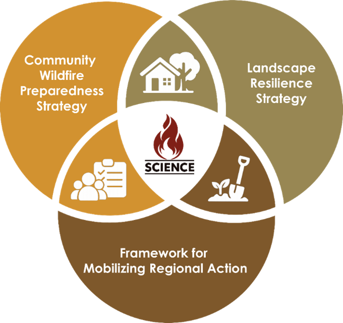
The Task Force provided an overview on the development of the 2026 California Wildfire and Landscape Resilience Action Plan, previewing how the Plan will provide a statewide framework to align investments and guide regional and local planning and implementation, with a focus on the measures that reduce risk at scale and improve long-term resilience. The Plan will include two complementary strategies: one focusing on reducing wildfire impacts in and around communities and one focusing on improving landscape health to lower the likelihood and consequences of high-severity wildfire. A statewide framework for mobilizing regional action will support both strategies by aligning planning, permitting, implementation, reporting, and funding—ensuring priorities translate into coordinated work that reduces fire intensity near communities, strengthens preparedness, and enables more efficient projects and expanded use of beneficial fire.

Sierra Nevada Regional Meeting 2026
Registration for In-Person Attendance is Closed.
Register for Field Tours by March 13.
Sierra Nevada Regional Meeting – Jamestown, CA
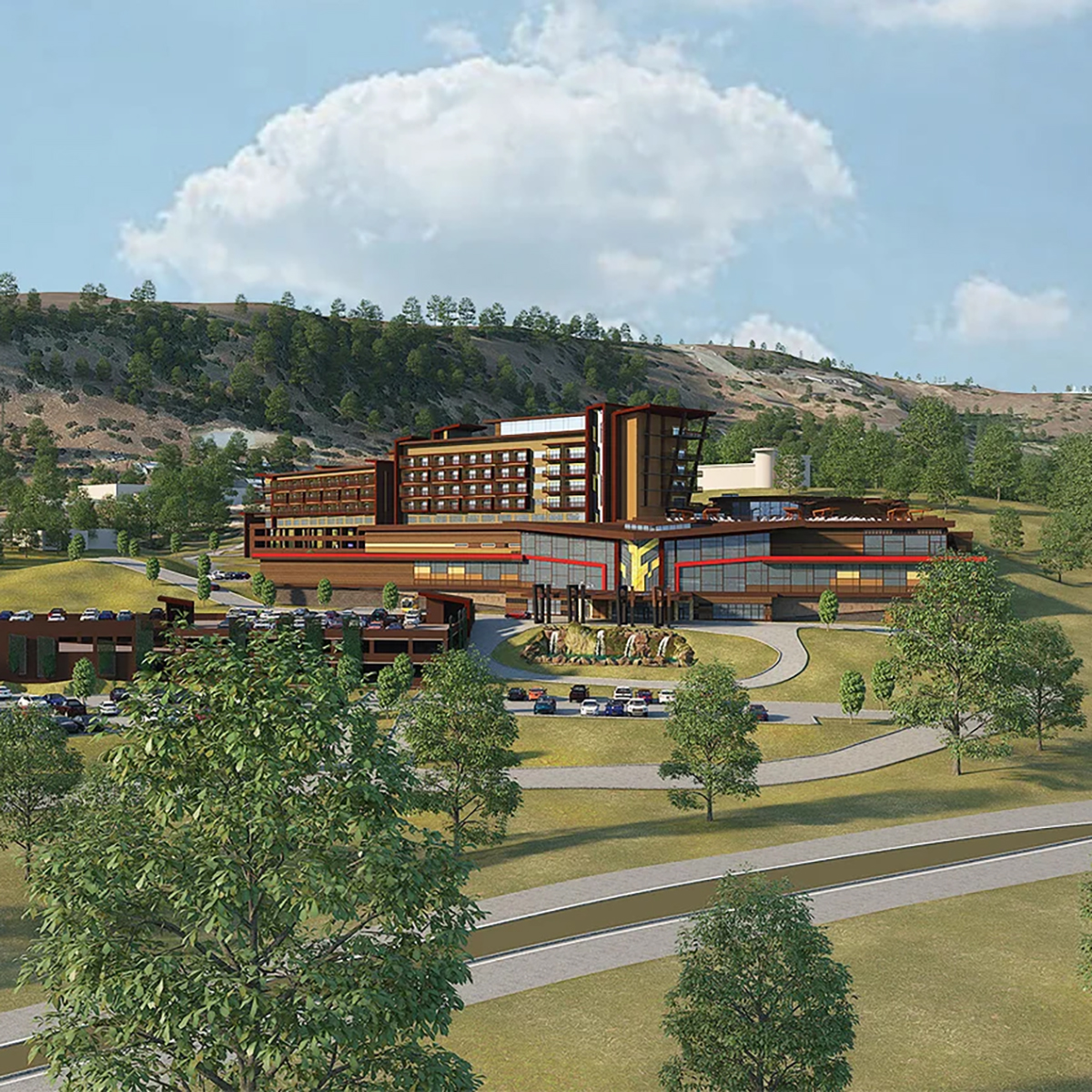
Mountain Counties Water Resources Association and Sierra Nevada Conservancy are hosting the California Wildfire and Forest Resilience Task Force Regional Meeting March 19 at the Chicken Ranch Casino Resort in Tuolumne County. A remote attendance option will be available via Zoom.
The meeting on March 19 will highlight issues of regional importance in the Central Sierra. We will kick off the day with refreshments and a resource fair. On March 20, Task Force partners will host field tours offering immersive opportunities to better understand the critical landscape health and wildfire resilience work being done in the region.
New Wildfire Task Force Merch Available
Purchase HERE, for pick up at the March 19 regional meeting.
(no mail delivery option.)
EVENT SCHEDULE
MARCH 19 MEETING SCHEDULE
Resource Fair
8:30 – 10:00 a.m.
Welcome, Land Acknowledgement, Opening Remarks
10:00 a.m. – 10:30 a.m.
Director’s Report
10:30 a.m – 11:00 a.m.
Morning Session: Achieving Resilience
11:00 a.m. – 12:15 PM
Lunch
12:15 p.m. – 1:30 p.m.
Afternoon Session 1: Sustaining Resilience
1:30 p.m. – 2:45 p.m.
Afternoon Session 2: Financing Resilience
3:00 p.m. – 4:15 p.m.
Closing Remarks
4:15 p.m. – 4:30 p.m.
Reception
4:30 p.m. – 6:30 p.m.
hotel information
Chicken Ranch Casino Resort
9100 People of the Mountain Rd.
Jamestown, CA 95327
209-984-9066
RESERVE YOUR ROOM
(Employee ID required on check-in)
field tours
ALL FIELD TOURS ARE FRIDAY MARCH 20
Tuolumne Bioenergy and Heartwood Biomass
Expanding Wood Products and Biomass Utilization in Tuolumne County
Destination: Join this tour of two of Tuolumne County’s newest wood-products facilities, Tuolumne Bioenergy and Heartwood Biomass. Both facilities boast state-of the-art technologies in the processing of forest biomass into multiple marketable products and were financed, in part, through grants from CAL FIRE and through the National Disaster Resilience Competition Grant.
Starting Point: Chicken Ranch Casino
Start/End: 9:00 AM – 1:00 PM
Accessibility: Tour will consist of walking around industrial facilities, potentially on uneven ground at times.
Additional Notes: Carpools encouraged. Bring your own water/snacks/lunch. Restrooms will be available.
Arnold Avery Healthy Forest Restoration Project
Prioritizing Community Wildfire Safety and Recreation Management
Destination: Bring your mountain bike or gravel bike for a fun ride on the Arnold Rim Trails to learn about the intersection between community wildfire safety and recreation management. Learn how active fuels reduction and prescribed burning projects in the wildland–urban interface adjacent to the community of Arnold have allowed for priotritization of outdoor recreation, forest health and wildfire safety.
Hear from the Arnold Rim Trail Association and the U.S. Forest Service about how they are advancing the shared goals of healthy forests, safe communities and fun recreational trails. This is a no-drop ride which means all are welcome as long as you have intermediate biking skills. We will have a sweeper for the group and will stop often to allow the group to catch up and help with any issues along the way. There are a couple small stream crossings to navigate. There are more trails in the area if you want to ride more. Our planned route is approximately 10 miles with 1,000’ of climbing. There will be a couple small stream crossings where your feet may get wet. We will cancel if snow or heavy rain affects the trails.
Start/End: 9:00 AM – 1:00 PM
Starting Point: See map pin
Accessibility: Mountain biking on gravel and native surface trails. Trails may be steep in some areas.
Additional Notes: Bring water/snacks/lunch. No restroom facilities along trail path. Leave Chicken Ranch Casino no later than 8am.
Social and Ecological Resilience Across the Landscape (SERAL) Project
A Collaborative Approach to Wildfire Protection and Forest Resiliency
Destination: View and discuss an all hands, all lands approach to community protection and forest resilience in the context of the SERAL Project and adjacent fuel treatment efforts. Stops will include examples of fuelbreaks and other fuel treatments to protect critical infrastructure, forest thinning and planned Rx burning treatments.
Starting Point: Twain Harte Market parking lot
Start/End: 09:30 AM -1:30 PM
Accessibility: Driving on maintained paved, gravel and dirt roads. Minimal walking just off of road side.
Additional Notes: Carpools encouraged; bring water/snacks/lunch; no restroom facilities after leaving meeting location.
Calaveras Big Trees State Park Beneficial Fire and Fuels Reduction
Collaborating to Reduce Wildfire Risk in a Giant Sequoia Forest
Destination: Hear from Calaveras Big Trees State Park Fire Management staff alongside local CAL FIRE Tuolumne-Calaveras Unit staff to learn about a brief park history, recent Wildfire and Forest Resilience Program funded fire and fuels work, and a Q&A session with local Park and CAL FIRE staff. This will be followed by a guided hike through giant sequoias to view recent prescribed burns along the 1.5 mile long ADA accessible North Grove Trail. This schedule may be slightly altered to accommodate inclement weather.
Starting Point: Jack Knight Hall, Calaveras Big Trees State Park
Start/End: 10:30 AM – 12:30 PM
Accessibility: 1.5 mile hike on ADA trail
Additional Notes: Carpools encouraged. Bring water and snacks. Restrooms will be available.
Rim Fire Reforestation and Restoration
Restoring Iconic Landscapes After Large-scale Wildfire
Destination: Join the Stanislaus National Forest and partners on a tour of the 2013 Rim Fire. Attendees will view the various restoration and reforestation strategies decided on by the Stanislaus National Forest and the Yosemite Stanislaus Solutions Forest Collaborative.
Starting Point: Groveland Ranger Station
Start/End:10:00 AM – 1:00 PM
Accessibility: Attendees must be prepared to walk short distances across uneven or steep terrain. Bring appropriate footwear and clothing for cold weather.
Additional Notes: Carpools encouraged. Bring your own water/snacks/lunch. Restrooms will be available at Ranger Station.
Yosemite National Park Fuel Treatments
Working Across Jurisdictions for Landscape-scale Fuel Reduction and Forest Management
Destination: Tour Yosemite Valley and giant sequoia forests to discuss landscape-scale fuel reduction and forest management implemented through mechanical and manual fuel treatments, prescribed fire, and Tribally-led fire and fuels work. Stops will examine how these approaches interact with wildfire and support the park’s goal of restoring good fire to the landscape to increase resilience. The tour will highlight how Tribal and Resource Conservation District partnerships are necessary to carrying out this work at scale across jurisdictions.
Starting Point: Chicken Ranch Casino
Start/End: 9:00 AM – 2:00 PM
Accessiblity: Attendees must be prepared to walk short distances across uneven or steep terrain. Bring appropriate footwear and clothing for cold weather.
Additional Notes: This is a one-way tour and will end on Highway 41 by Wawona. Only attendees traveling southward to return home should plan on joining this tour. Bring your own water/snacks/lunch. Restrooms will be available throughout tour.
Mokelumne Amador Calaveras Forest Health & Resilience Project
Planing for Large Landscape Fuels Reduction
Destination: Join the Upper Mokelumne River Watershed Authority (UMRWA) and the U.S. Forest Service for a tour of the Mokelumne Amador Calaveras Forest Health & Resilience Project (MAC Project) along the Highway 88 corridor in Eldorado National Forest. This tour will showcase ongoing and future fuels reduction and forest health treatments as part of this large-landscape green forest initiative. Participants will learn about treatment effectiveness, Tribal and other partner engagement, and lessons learned. The tour will begin at the Chicken Ranch Casino Resort. It will then proceed north to Jackson, CA, for a brief overview presentation on the project at the Amador County facility, and then participants will be led to several locations along Highway 88 on the Amador Ranger District to see recently treated areas and hear about future forest health treatments.
Starting Point: Chicken Ranch Casino
Start/End: 9:00 AM – 2:00 PM
Accessibility: Attendees must be prepared to walk short distances across uneven or steep terrain. Bring appropriate footwear and clothing for cold weather.
Additional Notes: Carpools highly encouraged. Participants will be able to leave vehicles in Jackson. Bring your own water/snacks/lunch and wear weather-appropriate clothing and footwear. Restrooms will be available early in tour.
THIS TOUR HAS BEEN CANCELED
Southwest Interface Team Wildfire Prevention
Defending Watersheds and Communities from Wildfire in Tuolumne and Mariposa Counties
Destination: Tour of Southwest Interface Team (SWIFT) area to learn how strategic fuelbreaks and fire prevention projects are helping to defend the watersheds, communities, and residents from wildfire in a 132,000 acre area in Southern Tuolumne and Northern Mariposa Counties. The collaboration, formed in 1999, is composed of local, county, state, and federal agencies, as well as non-profits and associations, working cooperatively to reduce the threat of wildfire. The tour will include projects focused on fuels reduction in an effort to achieve fire resilient landscapes.
Starting Point: Moccasin Schoolhouse, 1 Lakeshore Drive Moccasin, CA. (37.812040716786385, -120.30163409956883). From Moccasin Switchback Road take right at Hetch Hetchy Learning Center.
Start/End: 9:00 AM – 2:00PM
Accessibility: Attendees must be prepared to walk short distances across uneven or steep terrain. Bring appropriate footwear and clothing for cold weather.
Additional Notes: Bring your own water/snacks/lunch. Transportation provided for up to 20 attendees.
From Partnership to Scale: Financing Forest Resilience
Helping California Forest Landowners Thrive
Destination: Join the American Forest Foundation, utility partners, and local experts on this multi-stop field tour for discussions on fuels reduction projects highlighting CalFire Block grants, collaboration with electric utilities, and setting the stage for an innovative funding model to fund work on a larger scale.
Starting Point: Chicken Ranch Casino
Start/End: 9:00 AM – 2:00 PM
Accessibility: Attendees must be prepared to walk short distances across uneven or steep terrain. Bring appropriate footwear and clothing for cold weather.
Additional Notes: Carpools encouraged. Bring your own water/snacks/lunch.
Ponderosa Hills/Mira Monte Pilot Project
Implementing the California Wildfire Mitigation Program in Tuolumne County
Destination: Join California Wildfire Mitigation Project (CWMP) representatives and staff from Tuolumne County Office of Emergency Services touring the Ponderosa Hills/Mira Monte Pilot project created as part of the State of California’s effort to strengthen community-wide resilience against wildfires. The tour will look at the project area, relationship to local fuels reduction projects and discuss important measures that focus on cost-effective structure hardening and retrofitting to create fire-resistant homes as well as defensible space and vegetation management activities.
Starting Point: Chicken Ranch Casino
Start/End: 9:00 AM – 12:30 PM
Accessibility: Minor amounts of walking.
Additional Notes: Transportation will be provided from Chicken Ranch Casino. Bring your own water/snacks/lunch. Wear clothing appropriate for cold weather.

Thank You to our Sponsors


Inland Empire Resource Fair Vendors
Over 30 vendors participated in the Resource Fair!
CLICK THE NAMES BELOW TO FIND OUT MORE
-
Inland Empire Fire Safe Alliance
-
California Department of Insurance
-
Desert Region Fire Safe
-
UC Agriculture and Natural Resources (UC ANR)
-
BurnBot, Inc.
-
Forestry Educators Incorporated / Forestry Challenge
-
Ascent
-
The Forestry & Fire Recruitment Program (FFRP)
-
California Conservation Corps
-
Foundation for California Community Colleges
-
California Fire Safe Council
-
Headwaters Resiliency Partnership
-
TreePeople
-
American Forests
-
Southern California Wildfire Resilience Partnership
-
Southern California Mountains Foundation
-
CalTrans – Office of Natural Resource Managment
-
USFS
-
National Forest Foundation
-
SWCA
-
Dudek
-
Center for Community Action and Environmental Justice
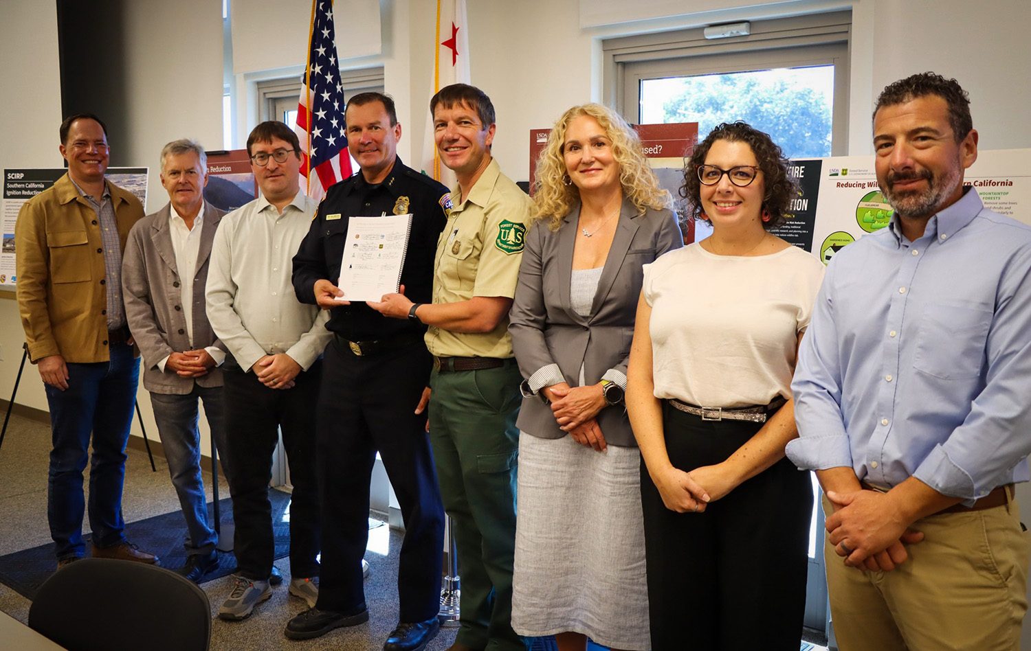
Interagency Partners Sign Charter to Reduce Wildfire Ignitions in Southern California
Interagency Partners Sign Charter to Reduce Wildfire Ignitions in Southern California
September 3, 2025 – Federal, state, and nonprofit partners, including the U.S. Forest Service, CAL FIRE, the California Department of Conservation, Caltrans, and the California Wildfire and Forest Resilience Task Force signed the Southern California Ignition Reduction Program (SCIRP) charter at the Southern California Geographic Area Coordination Center in Riverside. SCIRP is a public-private partnership created to reduce human-caused wildfire ignitions, particularly along roadways where nearly two-thirds of Southern California wildfires begin. The charter will reduce ignitions, lower costs, and limit wildfire impacts across jurisdictional boundaries.
With nearly 95 percent of wildfires in the region sparked by human activity, SCIRP was established in 2023 to directly confront wildfire risk. SCIRP’s mission is to systematically plan, fund, and carry out projects that reduce human caused ignitions while building public awareness and support. Its vision is a future where Southern California fires are limited to natural or beneficial ignitions, and roadways are lined with ignition-resistant materials and native plants.
The program is led by an Executive Committee that includes the U.S. Forest Service, Caltrans, CAL FIRE, and the California Department of Conservation, with advisory support from the National Forest Foundation, Blue Forest, and Conservation Investment Management.
California Allocates $9.5 Million for Wildfire County Coordinator Program
California Invests $9.5 Million for Wildfire County Coordinator Program
July 31, 2025 – With the support of Governor Newsom and the California State Legislature, the 2025-26 budget will provide $9.5 million for the Wildfire County Coordinator Program. Delivered in partnership between the California Fire Safe Council and CAL FIRE, the program establishes critical local capacity in 47 California counties with dedicated coordinators to secure funding, implement mitigation projects, engage vulnerable populations, and build resilience in high-risk communities. Coordinators serve as the crucial link between state strategy and local execution—ensuring California communities are better prepared, better connected, and more resilient to wildfire. The program will continue:
- Operationalizing California’s Wildfire and Forest Resilience Action Plan at the county level;
- Accelerating home hardening, defensible space implementation, and public education;
- Standardizing data collection to track local and statewide wildfire resilience progress; and
- Improving public safety, community insurability, and wildfire preparedness in California’s highest-risk regions.
Impact of the Wildfire County Coordinator Program
Investments in community capacity through the program have already produced substantial mitigation and resiliency benefits:
- Secured over $85M in funding for local wildfire mitigation projects;
- Coordinated with over 10,000 organizations to increase collaboration, break down silos, and leverage resources for community mitigation;
- Hosted over 3,800 events for community engagement and education;
- Educated and empowered over 800,000 residents to take action for wildfire resilience; and
- Established more than 100 new FireWise Communities and Fire Safe Councils.
Testimonials from the Wildfire County Coordinators
“The Program has allowed Del Norte County Fire Safe Council to protect many underserved residents and coordinate with other wildfire mitigation groups to maximize impact. Our County Coordinator has brought nearly $4 million in federal funding to Del Norte County, created defensible space around 372 homes, and completed 1,500 home assessments.”
– Aaron Babcock, Del Norte County
“A small investment in capacity can lead to sustainable, long-term improvements for any organization. Because of the County Coordinator Grant, Plumas Fire Safe Council had the capacity to obtain a $6.8 million dollar grant dedicated to hazardous fuels reduction and assessment.”
– Liam Gallaher, Plumas County
“The County Coordinator Grant has supported collaboration in our county by allowing us to create a collaborative meeting of 14 fire prevention agencies in the county to better inform the public and improve our ability to leverage funds and labor.”
– Jon Cottington, Madera County
“We’ve been able to significantly expand our youth education impact by implementing three new school programs and getting back into the classroom with students for the first time since the 2018 Camp Fire.”
– Lauren de Terra, Butte County
“The program has given us the time and opportunity to strengthen our outreach countywide while implementing critical fuel reduction programs. We’ve also been able translate educational materials into Spanish, expanding our outreach to underserved populations.”
– Marika Ramsen, Sonoma County
“We’ve reduced redundancy, supported capacity and collaboration for other Fire Safe Councils, and boosted community engagement through Firewise USA. We also learn from other County Coordinators & implement those lessons learned.”
– Stephen Watson, Ventura County
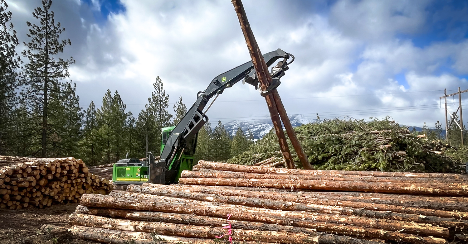
USFS Invests Nearly $8 Million in Wood Innovation Grants in California
USFS Invests Nearly $8 Million in Wood Innovation Grants in California
July 17, 2025 – The U.S. Forest Service announced awarding $80 million in Wood Innovations and Wood Product Infrastructure Grants to spur wood products manufacturing, expand active forest management, and accelerate energy innovation. Of these investments, nearly $8 million will go to 16 projects in California. A list of California awardees is below:
Wood Product Infrastructure Assistance Grant Program:
- Alpenglow Timber, LLC – $906,492: Establishes sawmill operations to support reduced wildfire risk and active forest management on National Forests and tribal forestlands in California and Nevada.
- California Hotwood, Inc. – $232,000: Upgrades firewood processing capacity to support reduced wildfire risk and active forest management on National Forests in California.
- Fall River Resource Conservation District – $252,642: Upgrades and modernization of biomass power facility operations to support reduced wildfire risk and active forest management on National Forests in California.
- Franklin Logging, Inc. – $907,568: Upgrades to lumber drying operations at sawmill to support reduced wildfire risk and active forest management on National Forests in California.
- Green Diamond Resource Company – $337,500: Establishes a stationary chipping facility to utilize small diameter and low value species in support of wildfire risk reduction and active forest management on National Forests in California.
- Lignum Support, LLC – $1,000,000: Upgrades and expansion of forest residues chipping operations for biomass energy to expand the utilization of forest residues and reduce wildfire risk and support active forest management on National Forests in California.
- Pacific Ultrapower Chinese Station – $960,000: Improves operational efficiencies at biomass power plant to support reduced wildfire risk and active forest management on National Forests in California.
- Tuolumne Biomass, LLC – $999,131: Upgrades small log processing operation to expand markets for small diameter and lower value species and support reduced wildfire risk and active forest management on National Forests in California.
Wood Innovations Grant Program:
- American Wood Fibers, Inc. – $300,000: Installs wood pellet mill to increase low-value wood utilization while supporting active forest management in California.
- DTE Materials Inc. – $300,000: Advances the production of wood concrete aggregates to improve utilization of low-value biomass and support active forest management.
- Enfilade Partners – $300,000: Designs and engineers a mass timber affordable housing project to accelerate the adoption of domestic mass timber thereby increasing active forest management and markets for small-diameter timber.
- Falk Forestry, Inc – $299,664: Establishes sawmill and firewood production to increase timber utilization and active forest management in Northern California.
- Fall River Resource Conservation District – $150,000: Establishes biochar production capabilities to support active forest management and wildfire risk reduction across national forests in California.
- Happy Camp Community Action, Inc. – $300,000: Advances the development of a new wood composite product to improve utilization of low-value biomass and support active forest management.
- Loamist, Co. – $300,000: Identifies locations for new low-value biomass markets to support active forest management and wildfire risk reduction in California.
- Sierra Institute for Community and Environment – $300,000: Installs mass timber manufacturing equipment thereby increasing active forest management across western forests.

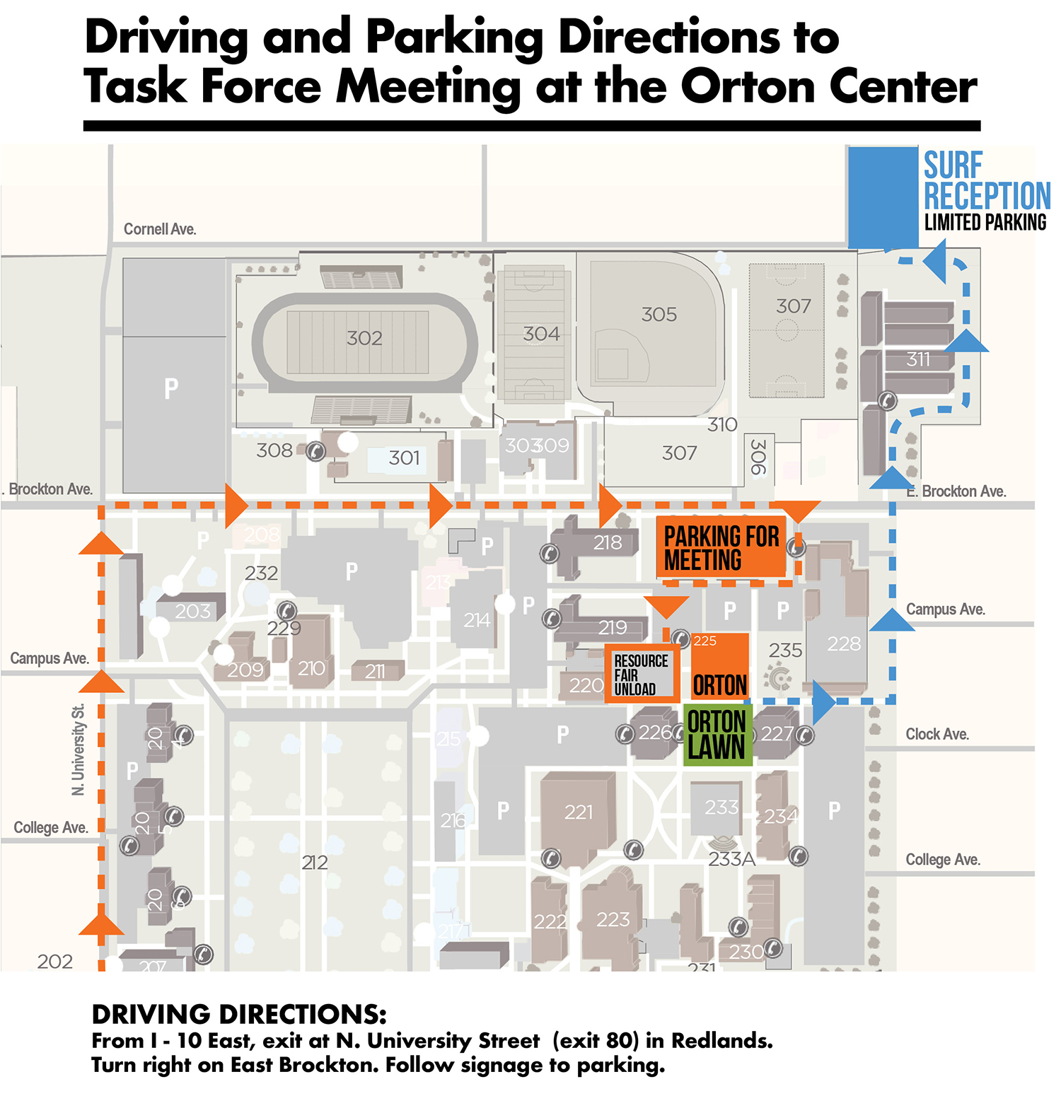
Registration Now Open for the Next Regional Meeting September 4-5
Inland Empire Regional Meeting
SEPTEMBER 4-5, 2025
The Inland Empire Community Foundation and the Inland Empire Resource Conservation District are hosting the California Wildfire and Forest Resilience Task Force Regional Meeting September 4 at the University of Redlands in San Bernardino County. A remote attendance option will be available via Zoom.
The meeting on September 4 will highlight the 2025 Action Plan and issues of regional importance. We will kick off the day with refreshments and a resource fair.
On September 5, Task Force partners will host field tours offering immersive opportunities to better understand the critical landscape health and wildfire resilience work being done in the region.
DRAFT EVENT SCHEDULE
September 4
– Resource Fair – 8:30 a.m. to 10:00 a.m.
– Morning Session – 10:00 a.m. to 12:15 p.m.
– Lunch – 12:15 p.m. to 1:30 p.m.
– Afternoon Session – 1:30 p.m. to 4:30 p.m.
– Reception – 4:30 p.m. to 6:30 p.m.
Inland Empire FIELD TOURS – September 5
North Big Bear Landscape Restoration Project
Implementing the Montane Forest Strategy as Fires Approach
Destination: Join the San Bernardino National Forest and Headwaters Resiliency Partnership to learn about the 13,000 acre North Big Bear Landscape Restoration Project, which focuses on forest health, water quality, and managing landscapes within the urban interface. The tour will visit wildfire scars near the project area and will include discussions on The Southern Montane Forest Conservation Strategy; conservation finance with Blue Forest and National Forest Foundation; and workforce development with Southern California Mountains Foundation and Urban Conservation Corps Crew.
Tour Host: USFS – San Bernardino National Forest
Location: Big Bear Discovery Center: 40971 North Shore Drive/Hwy 38, Fawnskin, CA 92333
Start/End Time: 9:30 a.m. to 2 p.m.
Accessibility: Limited walking on level terrain
Notes: Carpooling is encouraged; bring a packed lunch, water, sunscreen, and wear protective clothing for sun exposure.
Collaborative Conservation in the San Bernardino Mountain Foothills
Facing Ecosystem and Community Threats in Oak Glen and Yucaipa
Destination: Learn how public agencies, non-profits, and communities are working together toward wildfire resilience on this multi-stop tour in the San Bernardino Mountain foothills. The first stop at El Dorado Ranch Park will highlight the 2020 El Dorado fire impacts, recovery, and restoration. The tour will then head to Wildwood Canyon State Park to hear about a multi-partner restoration project that’s utilizing the Statutory Exemption for Restoration Projects (SERP) CEQA pathway. The tour will conclude at The Wildlands Conservancy’s Oak Glen Preserve to learn about local invasive issues like the Goldspotted Oak Borer and White Pine Blister Rust. Attendees are encouraged to further explore or grab lunch at the Preserve after the tour.
Tour Host: Inland Empire Resource Conservation District
Location: El Dorado Ranch Park: 37216, Oak Glen Road
Start/End Time: 8:30 a.m. – 12:30 p.m.
Accessibility: Some walking on dirt roads, uneven surfaces
Notes: Bring water, sunscreen, and wear protective clothing for sun exposure and walking on dirt trails. Attendees can purchase lunch at Los Rios Rancho at the final stop of the tour.
Santa Ana Mountains Holistic Risk Reduction
Grounding the Airport Fire and Preparing for the Next One
Destination: Visit the Cleveland National Forest to learn how firefighters leveraged holistic wildfire risk reduction efforts during the 2024 Airport Fire and how fire recovery is being implemented with the next fire in mind. The tour starts on the South Main Divide fuelbreak, where the fire was held before it could move into the densely populated areas of Riverside County around Lake Elsinore. The tour will also highlight a collaborative pilot project, led by CalTrans, for the Southern California Ignition Reduction Program. The tour will conclude with a visit to the CAL FIRE managed Los Pinos California Conservation Camp, which was successfully protected due to proactive vegetation management.
Tour Host: USFS – Cleveland National Forest
Location: California Wildland Firefighters Memorial Picnic Area: Immediate left from South Main Divide Road within 100 yards of Hwy 74.
Start/End Time: 10 a.m. – 12:30 p.m.
Accessibility: Limited walking on level terrain
Notes: Bring water, sunscreen, and wear protective clothing for sun exposure.
Upper Santa Ana Watershed & Seven Oaks Dam
Responding to Disasters and Opportunities in Water Management
Destination: Join the San Bernardino National Forest and Headwaters Resiliency Partnership to learn about connections between water management and community defense. This tour will explore damage from Tropical Storm Hilary, impacts from the Line Fire and will focus on how the Angelus Oaks Hazardous Fuels Reduction project demonstrates the effectiveness of fuel breaks. The tour will also visit Seven Oaks Dam and discuss water management opportunities.
Tour Host: San Bernardino Valley Municipal Water District
Location: Mill Creek Ranger Station (34701 Mill Creek Rd., Mentone, CA 92359)
Start/End Time: 9 a.m. – 3 p.m.
Accessibility: Limited walking on level terrain
Notes: Carpooling is encouraged; Bring a packed lunch, water, sunscreen, and wear protective clothing for sun exposure.
Thomas Mountain Prescribed Burn & Fuels Reduction
Protecting Communities and Habitats Through Collaborative Fuels Reduction Efforts
Destination: Come along on a tour of San Jacinto to see a collaborative approach to fuels reduction and community protection in the Southern Montane Forest that is enhancing and restoring critical habitat. The tour begins with a look at the Thomas Mountain Prescribed Burn and Fuels Reduction project and will then visit Inspiration Point where CAL FIRE, Idyllwild Fire, California State Parks and the U.S. Forest Service will demonstrate an interagency approach to fuels reduction and community protection.
Tour Host: USFS – San Bernardino National Forest
Location: Keenwild Ranger Station: 28500 Hwy 243, Mountain Center, CA 92561
Start/End Time: 9 a.m. – 2:30 p.m.
Accessibility: Short walks on paved and dirt roads
Notes: Bring water, sunscreen, and wear protective clothing for sun exposure.
Angeles National Forest Fuels Treatments Put to the Test
Hazardous Fuel Treatments Save Critical Infrastructure
Destination: Join Angeles National Forest Fire Personnel and local community members to learn how the Big Pines and Table Mountain Fuel Reduction projects protected their community in the midst of a raging fire inferno consuming everything in its path. The tour will explore before and after conditions of strategically planned fuel treatments implemented prior to the Bridge Fire and will include a guided discussion based on a fuel treatment monitoring report and testimonials. The tour will also highlight how the network of fuel treatments around NASA JPL, numerous organizational camps and Big Pines aided firefighters to save the vast majority of infrastructure in the area.
Tour Host: USFS – Angeles National Forest
Location: Table Mountain Campground: 22223 Big Pines Hwy, Valyermo, CA 93563
Start/End Time: 9 a.m. – 12:30 p.m.
Accessibility: Mostly short stops walking on even terrain
Notes: Bring water, sunscreen, and wear protective clothing for sun exposure.
Eaton Fire Response and Recovery
Community Preparedness for Santa Ana Winds
Destination: Hear from local, county and federal partners on their experiences in preparation, initial attack, and recovery during and after the Eaton Fire. Learn about the operational complexities in a mutual threat zone and how the Eaton Fire quickly burned across city, county, state, and federal jurisdictions and became an urban conflagration destroying thousands of structures. Join field commanders on a tour through the impacted community of Altadena, from the area of the fire’s origin through the far reaches of the urban conflagration.
Tour Host: USFS – Angeles National Forest
Location: Angeles National Forest Supervisor’s Office: 701 N. Santa Anita Ave. Arcadia, CA 91006
Start/End Time: 9:30 a.m. – 12:30 p.m.
Accessibility: Limited walking on level terrain
Notes: Bring water, sunscreen, and wear protective clothing for sun exposure.
Tour of Esri Headquarters in Redlands
Explore Wildfire Innovation at Esri’s Geo Experience Center (GeoXC)
Destination: Join us for an immersive visit to Esri Headquarters in Redlands, CA, where participants will tour the Geo Experience Center (GeoXC) and engage with cutting-edge GIS and location intelligence technologies that are transforming wildfire resilience across California and around the world. This interactive experience will feature live demonstrations of spatial dashboards, satellite-enabled fire alerting and progression displays, and rapid detection tools that support real-time situational awareness. Attendees will also explore how GIS is being used to assess and enhance defensible space, empowering communities to prepare for and mitigate wildfire risks. This will be an opportunity to see how geospatial innovation is supporting wildfire preparedness, mitigation, and response.
Tour Host: ESRI
Location: 380 New York Street- Redlands, CA 92373
Start/End Time: 9:00 a.m. – 11:00 a.m.
Accessibility: No accessibility limitations
Notes:
hotel information
Questions? Please contact foresttaskforce@fire.ca.gov
Thank You to our Hosts
Thank You to our Sponsors