
California Wildfire + Landscape ResilienceInteragency Treatment Dashboard
Recently Updated with 2024 Data
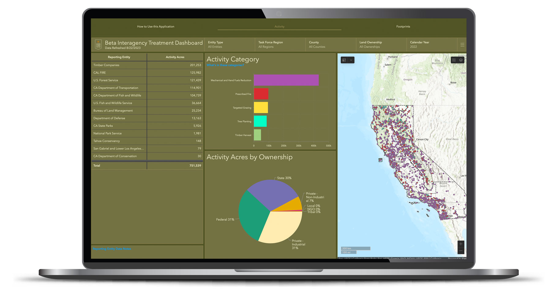
As California works toward ambitious wildfire and landscape resilience goals, transparency and effective planning tools are critical to success. The California Wildfire and Landscape Interagency Treatment Dashboard, for the first time ever in California, provides a single source for displaying recently completed forest and wildland projects from over a dozen different federal and state agencies.
What is the Wildfire & Landscape Resilience Interagency Treatment Dashboard?
The Dashboard is a first-of-its-kind platform that displays the location and size of federal and state wildfire and landscape resilience treatments throughout the state. The Dashboard is a highly interactive online tool by which users can sort treatments by region, county, land ownership, and more. By charting the work of what has been accomplished to date, the Dashboard can be used to guide practitioners on where to plan new projects.
Instructional Video
This video offers a brief overview of the Treatment Dashboard, and walks you through the key functionality.
FAQs
The Interagency Treatment Dashboard is a first-of-its-kind platform that will document progress toward various state and federal treatment targets, specifically:
- Treat 500,000 acres of USFS land annually by 2025 (Source: Wildfire and Forest Resilience Action Plan; Shared Stewardship Agreement)
- Treat 500,000 acres of non-federal land annually by 2025 (Source: Forest Carbon Plan; Executive Order B-52-18; Wildfire and Forest Resilience Action Plan; Shared Stewardship Agreement)
- Manage 175,000 acres of National Park Service land by 2025 (Source: Wildfire and Forest Resilience Action Plan)
- Treat 10,000 to 15,000 acres of Bureau of Land Management land annually by 2025 (Source: Wildfire and Forest Resilience Action Plan)
- CAL FIRE will treat 100,000 acres annually of the State’s 500,000-acre target by 2025 (Source: Wildfire and Forest Resilience Action Plan)
- Land managers will deploy beneficial fire on 400,000 acres annually, according to the following estimates (Source: California’s Strategic Plan for the Beneficial Use of Fire)
- CAL FIRE: 50,000 acres
- USFS: 150,000 acres
- National Park Service: 20,000 acres
- Bureau of Land Management: 5,000 acres
- State Land Managers (excluding CAL FIRE): 25,000 acres
- Range Improvement Associations: 25,000 acres
- Other land managers: 25,000 acres
There are two ways that vegetation treatment data can be counted, both of which are displayed in the Dashboard:
- Footprint acres are calculated through spatial analysis to ensure an acre that experienced one or more treatments is only counted once annually.
- Activity acres track every treatment action, including those that occurred in sequence on the same acre over time. For example, a thinning project may have been conducted on an acre prior to a prescribed burn.
We are measuring progress toward acreage targets based on “footprint acres” because this metric best captures the geographic areas that were treated during the year.
However, we are also tracking and reporting “activity acres” which better captures the level of effort conducted through various state, federal, and private programs. This also helps demonstrate the importance of multiple treatments on individual landscapes.
The Dashboard includes all federal and state agency vegetation management projects, and those of large private timber operations, which are state regulated activities. Moving forward, the Task Force will also capture local and tribal projects. CAL FIRE is working with industry partners on an agreement to regularly collect treatment data from industrial forest landowners.
- We still lack data from some California Natural Resource entities, most notably Wildlife Conservation Board, Sierra Nevada Conservancy, and California Conservation Corps.
- Acres are tracked by ownership to avoid double counting of projects with multiple funding sources.
> Reporting Entity Data Notes (pdf)
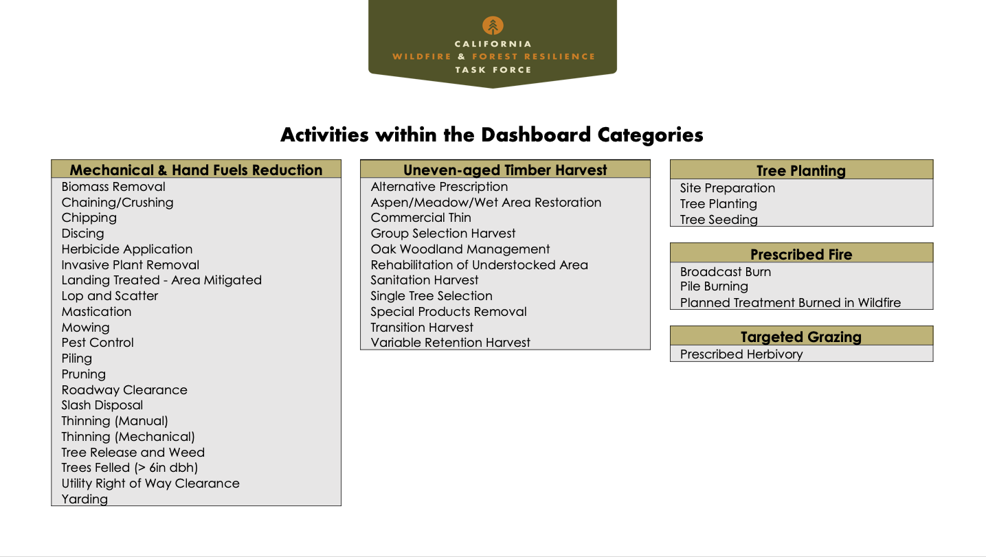
Approximately 60 different activities are displayed in the Dashboard. They are grouped into several categories including forest health and fuels reduction (e.g., thinning, chipping), prescribed fire, targeted grazing, uneven-aged timber harvest, and tree planting.
- Version 2.0 now includes data from 2024.
- Data from 2021-2023 have been updated to reflect the most updated numbers from partner datasets. Lags in data reporting at the organizational level (i.e. a March 2024 deadline for submitting 2023 data) mean that it may take a year or two for total annual acreage to stabilize. This can be especially pronounced when treatment data is working its way from a grantee to a funding organization, to that funding organization’s parent databased and then, finally, into the Interagency Tracking System.
- Data from all years may now be viewed simultaneously in the Dashboard.
- Data trends across years may now be visualized in the Dashboard.
- Task Force Regional boundaries have been updated.
The Task Force’s Monitoring and Assessment Work Group conducted a comprehensive effort to develop a reporting and tracking system that would best align the various systems and inherent data of federal, state, local agencies and private landowners.
- Multiple agencies funding the same projects: Most projects are funded or completed by more than one agency, but each agency reports them in their own system. As a result, the Task Force has had to collect and analyze spatial (geographic) data from hundreds of projects to avoid double counting of these projects.
- Pre-existing systems: CAL FIRE and federal land managers each have their own systems, which use different definitions, categories, and time periods.
- Timing: The agencies update their data at different times throughout each year, and generally review and finalize them following the state and federal fiscal years. This system provides a calendar year view.
- Lack of data: Many smaller federal and state agencies haven’t collected spatial data from their grantees.
Treatment acres reported in CAL FIRE’s Fuel Reduction Projects Viewer may differ from those displayed in the Dashboard. The Dashboard is based on calendar year, includes a wider suite of activities, such as tree planting, and only reports work measured in acres. CAL FIRE’s Fuel Reduction Viewer, is based on the state fiscal year (July-June), only includes treatments related to fuels reduction, and includes work measured in units such as hours or tons.
Supporting Documentation*
- System Framework & Data Dictionary (pdf)
- Dashboard Instructions For Use (pdf)
- Activity within Dashboard Categories (pdf)
- Data Conversion & Reporting Methods (pdf)
- Reporting Entity Data Notes (pdf)