
Roadmap to a Million Acres
OVERVIEW
The Wildfire and Forest Resilience (WFR) Task Force is developing a comprehensive strategy, the Roadmap to a Million Acres (Figure 1), to scale up our collective efforts to treat a minimum of one million acres annually by 2025. As shown below, the Roadmap includes three key elements: 1) state-wide interagency strategies that align the work of federal, state, local, and tribal governments; 2) an interagency tracking system and Forest Data Hub to provide consistent data systems to track progress and assess the condition of our landscapes; and 3) a regional framework for investing in programs and projects tailored to the priorities and risks in each region.
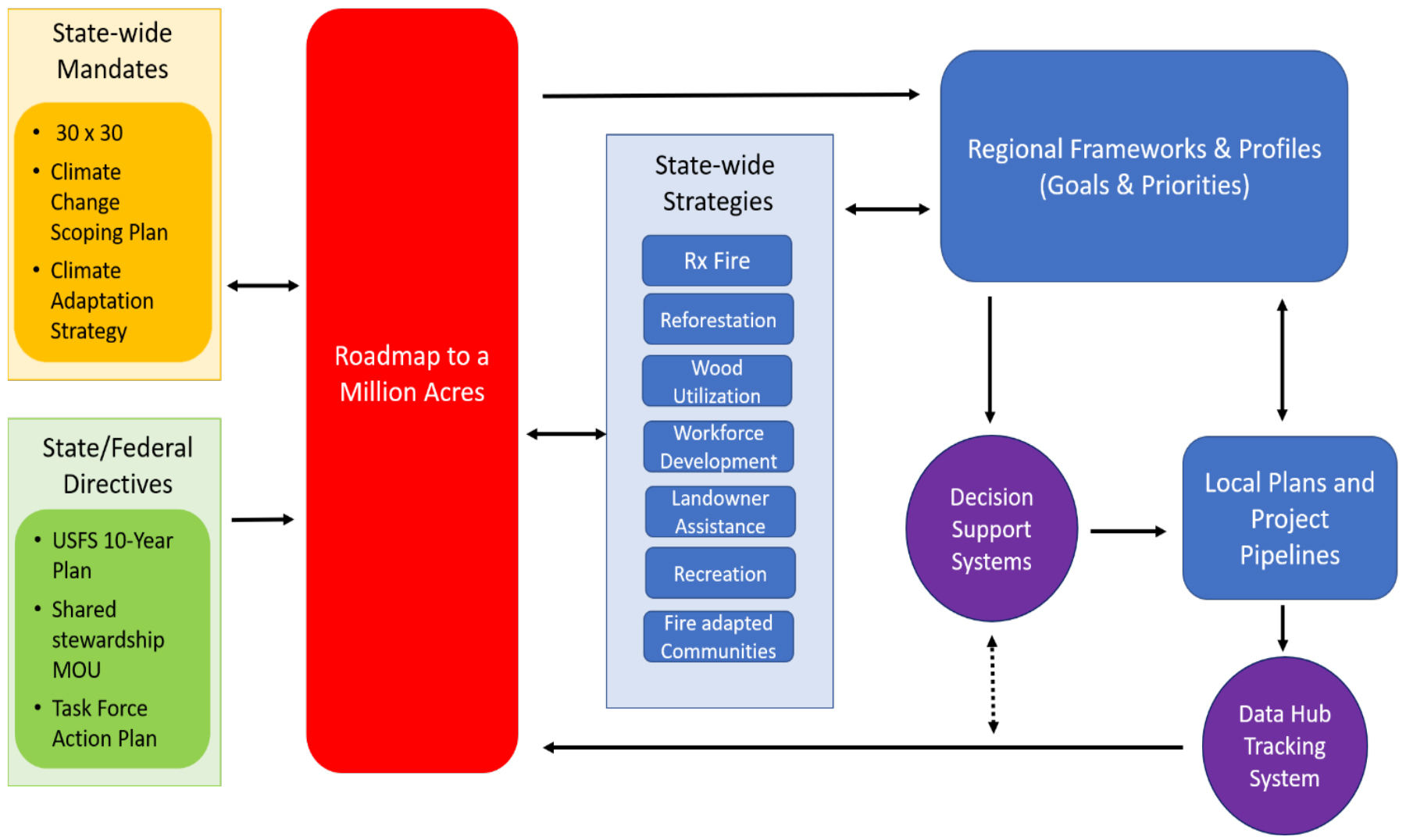
1. STATE-WIDE INTERAGENCY STRATEGIES
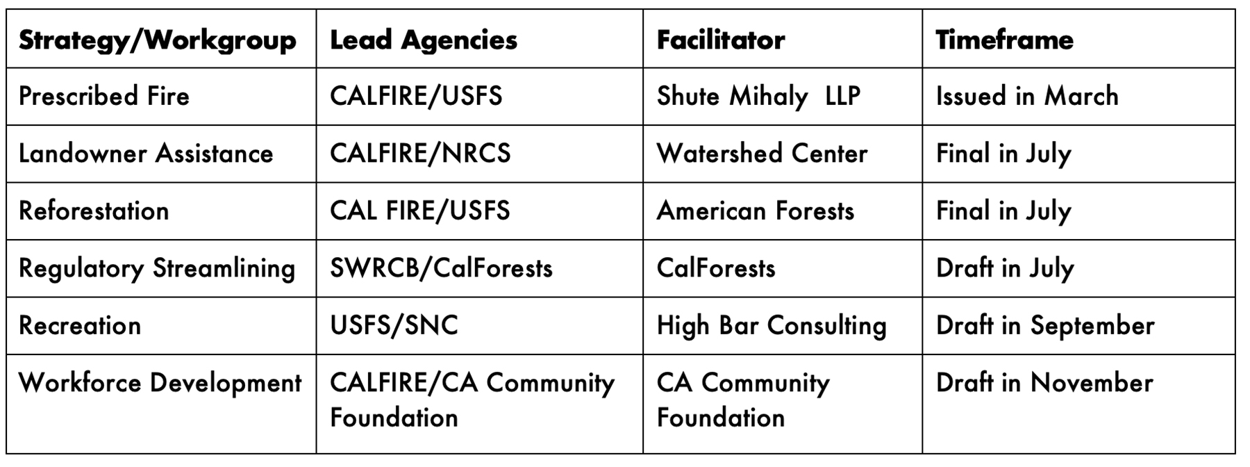
These state-wide strategies set aggressive but achievable targets for a broad range of interagency programs, from prescribed fire to reforestation and private landowner assistance. They also focus on reducing logistical barriers, addressing policy issues, and aligning federal, state, and local efforts — functions essential to meeting the annual million-acre goal. As shown below, these strategies will be largely completed by the end of 2022.
2. DEPLOYMENT OF DATA AND ANALYTICS
To provide common measures of progress and consistent information for planning and tracking, the Task Force is developing three linked information services: an interagency tracking system of recently completed and planned projects state-wide, a common set of metrics to define and measure forest and wildland resilience, and a Forest Data Hub that functions as a clearinghouse for data and reporting systems.
Interagency Tracking System: This system will include both summary information on statewide activity to measure progress towards the million-acre target, and a spatial “dashboard” of treatments that will help land managers and others align federal, state, local, tribal, and private projects throughout the state. The system will be built in stages, with an initial focus on compiling data from larger state, federal, and private reporting systems, and later phases capturing all projects through a mobile app-based system. The Task Force will report on its initial findings at the July 2022 meeting.
Metrics and Assessments: The Task Force is working to align a broad range of agency efforts to define forest and wildland resilience. This alignment will assist local and regional collaboratives in setting priorities and measuring performance beyond acres treated. Alignment of restoration efforts revolves, in part, around collaboration in the development and interpretation of relevant spatial data that quantify a large array of landscape characteristics and conditions. Key components of this work include:
● Framework for Resilience: CalFire and the USFS, in coordination with the UC Berkeley Center for Law, Energy, and Environment (CLEE), are leading the development of a comprehensive set of measurable indicators of forest and wildland resilience. Originally developed as part of the Tahoe-Central Sierra Initiative, these include a draft set of ten “pillars” or objectives, including forest resilience, fire-adapted communities, biodiversity conservation, carbon sequestration, water security, air quality, wetland integrity, economic health and diversity, and social and cultural well-being (Framework for Resilience).
● Metrics: The agencies are also developing a comprehensive set of metrics to provide a common method for measuring and assessing landscape conditions and to enable progress towards the pillars of resilience. Examples of common metrics that can be tracked over time for example: probability of fire severity, at-risk infrastructure, tree mortality, carbon storage, runoff production, disturbance intensity, and species richness.
● Assessment of Forest Conditions: An interagency team, in partnership with the Center for Ecosystem Climate Solutions (CECS), is developing a series of regional assessments of forest condition. These assessments will evaluate conditions with respect to each pillar of resilience. Pillars will be quantified using a vetted set of common metrics. These metrics will include measures of landscape condition gathered from a variety of sources. For example, many of the vegetation structure and composition metrics will come from the F3 product (U.S. Forest Service Region 5 Remote Sensing Lab), which relies on both field and remote sensing data to extrapolate the details of Forest Inventory and Analysis (FIA) plots to a spatially contiguous landscape. The ACCEL project will be deriving a range of additional metrics based on the F3 data products, such as wildlife species richness and forest heterogeneity. CECS will contribute additional metrics based on their remote-sensing-informed, ecosystem process model. Importantly, CECS products are spatially and temporally compatible with the F3 data layers. Additional metrics are being generated by State programs, such as measures of the probability of fire severity. All data used in these assessments will be open-sourced and publicly available. Information for each pillar will include both the current condition, as well as the difference between the current state and a collectively defined target condition that represents a resilient state. These assessments will be visualized as a series of “heat maps”, i.e. spatially explicit values that indicate departure of current conditions from a target condition, for each pillar across the region of interest.
Integration with Decision-Support Systems: Forest collaboratives and regional partnerships are using a variety of public and private systems to inform the project prioritization process and develop landscape-scale strategies. The Task Force and its partner agencies will continue to support these diverse efforts but will also seek to ensure they are linked to the assessments and a common set of metrics described above. This approach will provide flexibility for regional partnerships to choose their own decision-support tools while ensuring that the Task Force and its partner agencies have a consistent yardstick for measuring progress at the regional and state-wide levels.
Forest Data Hub: The Task Force Monitoring, Reporting, and Assessment workgroup, in coordination with the Climate and Wildfire Institute (CWI), is overseeing the development of a Forest Data Hub to support the critical data needs associated with planning, implementing, and tracking state-wide forest management and conservation goals. The Data Hub will include:
● The interagency accounting system of completed and planned treatments by landowner, region and subregion throughout the state;
● A repository of scenario planning and data management efforts (e.g., the Air Resources Board Scoping Plan Update, the CA Fifth Climate Change Assessment, Pathway to 30×30);
● A federated data system that integrates a broad range of agency, academic, and local databases (e.g., zoning, building restrictions, impaired waterbodies); and
● An online data server that provides rapid and reliable access to the data and other scientific information needed by land managers and decision-makers.
3. REGIONAL CAPACITY
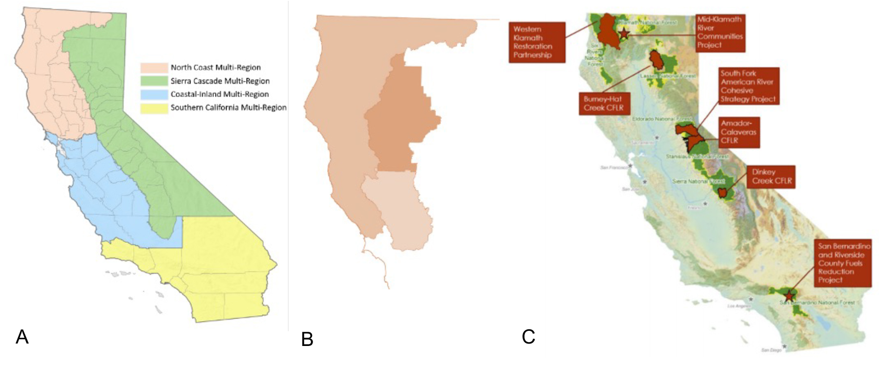
As described in the Wildfire and Forest Resilience Action Plan, the Task Force will seek to expand and strengthen the growing network of regional collaboratives and partnerships to help build the state’s capacity to treat at least a million acres annually. As described above, the Task Force will develop a common framework to assess landscape conditions, identify priority areas, measure progress, and accelerate the work of local and regional partnerships while enabling each region to address its own risks and priorities through landscape scale strategies. As shown in Figure 2, the Task Force will help coordinate these capacity building efforts at multiple scales across the state.
Regional Profiles: The Science Advisory Panel will develop a series of Regional Profiles that summarize the risks, interdependencies, and opportunities in achieving resilient forests, chaparral, and community protection. These profiles will provide scientifically robust, region-specific context to inform decision-makers, stakeholders, and the public on the key priorities and issues in each region.
Regional Resource Kits: The Task Force will work with its regional partners to develop a series of Regional Resource Kits to jumpstart capacity and accelerate implementation in each region. Beginning with the Sierra Nevada region on September 27th, the Task Force will present the first of these resource kits. At each of the subsequent regional meetings of the Task Force the remaining three Regional Resource Kits will be released. These resource kits will be jointly produced by the same interagency and academic team synthesizing core metrics and assessments (see Metrics and Assessment sections above). Each kit will include the following:
● Metrics: A core set of metrics used to quantify the pillars augmented by regionally specific information.
● Pillars: A common-language description of each pillar along with a workflow used to quantify each pillar.
● Regional Priorities and Management Opportunities: An integrated package of mapped products that includes the condition assessments by pillar (i.e., “heat maps”), recently completed and planned treatments, collaborative boundaries, critical infrastructure and other contextual map data (e.g., building footprints, transportation routes, and sensitive species habitats). Collectively, these maps can be explored to identify areas where investments are being made and find additional areas that would greatly benefit from investments.
● Regional Demonstrations: Case studies that demonstrate how available data, metrics and analytics (i.e., the Regional Resource Kit) can be used to help local and regional planning efforts (e.g., the landscape-scale strategy developed by the SERAL project and subregional strategy developed by the Tahoe Central Sierra Initiative in the Sierra Nevada).These demonstrations are aimed at illustrating some of the analytical approaches and decision support that are possible with the data and tools available to local planning efforts.
Regional Landscape Investment Program: The Task Force will develop an interagency landscape investment program that leverages federal, state, and local funding to support development and implementation of Regional Priority Plans (RPPs). These RPPs will be focused on developing pipelines of projects and 5- to10-year programs of work to provide the sustained levels of funding and capacity building necessary to increase the pace and scale of forest and wildland health treatments.
The initial focus will be on aligning USFS, CAL FIRE, state conservancy funding, but will be broadened over time to include other agencies. For example, the Wildlife Conservation Board (WCB), Department of Fish and Wildlife (DFW), Department of Water Resources (DWR), and other agencies could provide funding to RPPs that address their mandates and priorities at a landscape scale. This approach will enable regions to attract funding from several agencies and help facilitate alignment and integration of state and federal mandates at the regional level.
The Sierra Nevada Conservancy, in coordination with the USFS and other federal, state, and local agencies, will lead the development of a regional investment strategy for the Sierra Nevada region at the September Task Force meeting, and others will be developed for each of the subsequent quarterly regional meetings.The proposed approach will include the following key elements:
1. Identify Priority Areas: In each of the four major regions of the state, the Task Force partner agencies will identify priority areas for investments based on the findings of the science team and an assessment of the capacity of regional partnerships. These are likely to include areas now developing Regional Priority Plans through RFFC or SNC funding, and areas developing similar plans under related programs, such as the USFS Collaborative Forest Landscape Restoration Program (CFLRP).
2. Award Landscape Grants:
• In priority areas with completed RPPs, CAL FIRE, the USFS (through NFWF), and the conservancies will jointly provide grants of $10 million or more over 5-10 years.
• To be eligible for these grants, RPPs must meet the criteria established by the state’s Regional Fire and Forest Capacity (RFFC) Program, and by the requirements tied to each source of funding.
• To date, regional partnerships receiving landscape grants consistent with this approach include the North Yuba Forest Partnership (USFS: $m) , Stanislaus National Forest (USFS: $m), Dinkey Collaborative Forest Landscape Restoration Project (Sierra National Forest)(USFS: $m), and the North Coast Regional Partnership (CAL FIRE: $10 million).
3. Establish NEPA/CEQA Teams:
• The National Fish and Wildlife Foundation (NFWF), in partnership with the state’s RFFC Program, will establish interdisciplinary teams for each of the partnerships awarded landscape grants to accelerate the environmental review processes and permitting of their priority projects.
• More…
4. Award Planning/Capacity Building Grants:
• In other priority areas, the Department of Conservation, in partnership with the USFS (through NFWF) and the conservancies, will continue to fund the development of RPPs to build a pipeline of projects at a landscape scale.
• Consistent with the draft guidelines issued by the Department of Conservation, RPPs should be focused on the key priorities and risks in their respective areas, but must also include the following common elements:
• Geography and Governance: RPPs must address the unique geographic, biophysical, and social characteristics of their region and the governance structure necessary to effectively develop and implement the plan with broad-based support.
• Assessment and Methodology: RPPs must include an assessment of landscape condition, a methodology for decision making, and a program for evaluation of ongoing activities that are consistent with the metrics and assessments developed by the Task Force interagency science team.
•Landscape Portfolios of Projects: RPPs must include lists of priority projects that, taken together, respond to landscape scale wildfire and ecosystem health priorities.
•The following areas are currently developing Regional Priority Plans:
• North: North Coast Regional Partnership, Tehama, Napa
• Sierra Nevada:
• Central:
• South: Santa Monica, Inland Empire, and San Diego