
California Unveils First-ever Statewide LiDAR Maps
California Unveils First-ever Statewide LiDAR Maps
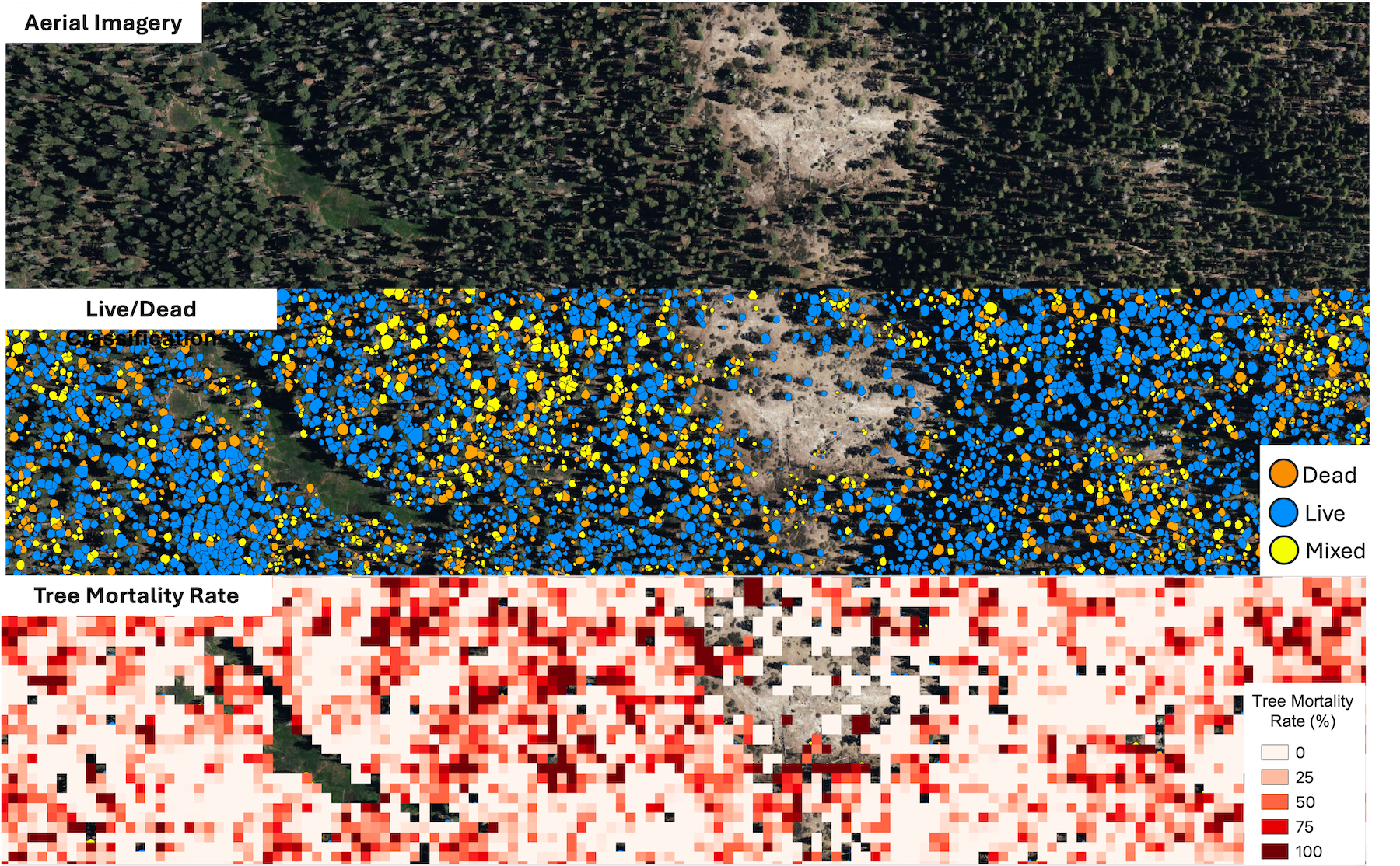
December 12, 2025 – The California Natural Resources Agency (CNRA), in partnership with the California Air Resources Board (CARB), NASA Ames Research Center, and the Wildfire and Forest Resilience Task Force announced the public release of consistent, statewide datasets on forest and vegetation conditions built from LiDAR, the gold standard for forest and vegetation information. This release is powered by the Wildfire, Ecosystem Resilience, and Risk Assessment Initiative (WERK) which has processed more than 100 million acres of LiDAR data across California. That total includes 40 million acres collected through CNRA’s use of $30M dedicated by the State Legislature for wildland remote sensing. For the first time, California has a single wall-to-wall picture of forest and vegetation conditions that is the highest resolution available and consistent across the entire state. Agencies, tribes, researchers, land managers, and community partners can begin incorporating the released products into their own tools, models, and planning processes immediately.
LiDAR (light detection and ranging) creates detailed three-dimensional maps of the landscape. Using LiDAR, the WERK initiative provides information on where trees and shrubs are, how tall and dense they are, where ladder fuels can carry fire into the canopy, and how much carbon is stored in vegetation. The statewide release includes 10-meter and 30-meter resolutions datasets that cover all of California. In addition, 1-meter datasets are already available in select areas, with statewide access to ultra-high resolution data launching in early 2026.
The WERK datasets are being hosted in partnership with the Wildfire Science & Technology Commons at the San Diego Supercomputer Center, supported by the National Science Foundation. These products will also be incorporated into the Task Force’s California Landscape Metrics beginning with the next data refresh.
Governor Newsom Signs Executive Order to Expand Beneficial Fire Use
Governor Newsom Signs Executive Order to Expand Beneficial Fire Use
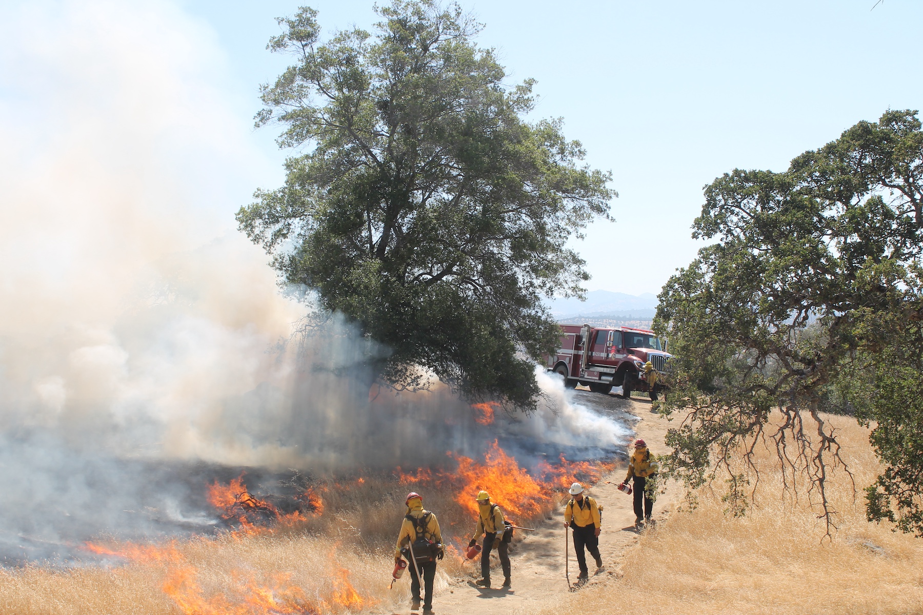
October 29, 2025 – Governor Newsom signed an executive order directing state agencies to reduce red tape and expand tools to safely deploy beneficial fire projects. The order directs a suite of actions to fast-track critical work in the coming months with a key focus on directing state agencies to provide immediate on-the-ground support to local governments and fire practitioners to maximize use of beneficial fire, helping ensure that California does not miss the critical fall weather window to conduct prescribed and cultural burns. The order supports collaborative efforts to update beneficial fire permitting, address air quality concerns associated with smoke and enable resource conservation districts and other entities to carry out beneficial fire projects.
The executive order helps strengthen and build on California’s wildfire prevention strategy by:
- Accelerating funding and projects: Distributes funding to resource conservation districts and other eligible government agencies in advance of beneficial fire work, as well as creates more simplified grant funding processes.
- Expanding local participation: Removes policies and regulatory roadblocks that would make it more difficult for local agencies to engage in this work, including suspending the state law that prohibits resource conservation districts and volunteer fire departments from participating in the Prescribed Fire Liability Claims Fund Pilot Program.
- Working with tribal communities: Directs state agencies to continue prioritizing tribal consultation, access, collaboration, and co-management—so we can work together to expand and support cultural burning and other forms of tribal stewardship.
- Increasing education and data: Directs the California Air Resources Board (CARB) to create new modeling and related technologies, such as the Prescribed Fire Information Reporting System (PFIRS) and make this technology available to support air districts’ efforts to promote fast, efficient and low-cost permitting, and expands training opportunities for beneficial fire practitioners.
- Mitigating air quality risks: Increases collaboration and creates new best practices that provide beneficial fire practitioners consistent permitting and smoke management plan guidance while protecting public health and communicating potential smoke impacts to the public and create guidance for local communities.
Building on nation-leading progress
The executive order builds on unprecedented progress already made by state, federal, tribal, local, and nonprofit partners to increase the pace and scale of beneficial fire implementation across the state. Key advancements include:
- The Task Force issued California’s Strategic Plan for Expanding the Use of Beneficial Fire (2022), a comprehensive roadmap to coordinate the efforts of state, federal, and tribal partners to treat up to 400,000 acres with beneficial fire annually by 2025.
- Prescribed fire treatments in California nearly doubled between 2021 and 2023. Federal, state, and local agencies completed 260,000 acres of prescribed fire treatments in 2023.
- In May, CAL FIRE, for the first time ever, met and exceeded its 50,000-acre goal for beneficial fire as outlined as a goal within the California Strategic Plan for Expanding the Use of Beneficial Fire. This was accomplished even with the Park Fire in late 2024 and the January 2025 fires in Los Angeles.
- As of June, CARB, in close coordination with the California Air Pollution Control Officers Association, has held over 20 prescribed fire training sessions for stakeholders to discuss smoke management, public information, and tools and technology related to prescribed fire.
- In 2021, CARB released California Smoke Spotter — a critical tool to inform the public of air quality impacts from wildfire and prescribed fire smoke.
- The Governor and Legislature established a first-in-the-nation Prescribed Fire Liability Claims Fund in 2022 backed with $20 million in state funding, to accelerate beneficial fire on private lands by covering losses in the rare instance that a prescribed or cultural burn escapes control.
- In September 2024, Governor Newsom signed SB 310, which reduces barriers for California Native American tribes to conduct cultural burns in their ancestral territories. The Karuk Tribe and the California Natural Resources Agency (CNRA) entered into the landmark SB 310 Cultural Fire agreement in February 2025. Out of this effort, the Tribe and CNRA have developed a template agreement for other tribes to utilize educational materials to support government-to-government collaboration in advancing cultural fire.
- In September 2024, Governor Newsom signed SB 1101, which streamlines CAL FIRE’s contracting and procurement process to support beneficial fire.
- In August 2023, the Governor’s Wildfire and Task Force launched an Interagency Treatment Dashboard that provides transparency on the location of completed beneficial fire projects.
- CAL FIRE’s Prescribed Fire Monitoring Program released the first version of a manual outlining field monitoring protocols in 2023 to assist land managers with unit selection, data collection, tools and technologies, data storage, and analysis procedures.
Governor Newsom Unveils California’s Updated Climate Adaptation Strategy
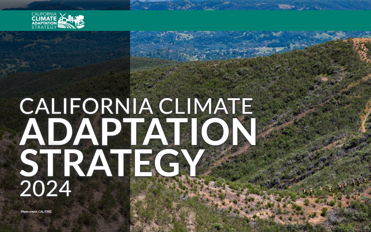
Governor Newsom Unveils California’s Updated Climate Adaptation Strategy
September 4, 2025 – Governor Newsom unveiled California’s updated Climate Adaptation Strategy — the state’s overarching framework to better protect communities and nature from dangerous climate impacts. California last updated the Strategy in 2021. The updated strategy sets strategic direction through six priorities:
- Protecting communities most vulnerable to climate change
- Improving public health and safety to protect against increasing climate risk
- Building a climate-resilient economy
- Expanding nature-based climate solutions and strengthening the resilience of natural systems
- Making decisions based on best available climate science
- Partnering and collaborating to leverage resources
These priorities are supported by cross-cutting climate resilience actions, each with associated success metrics. The strategy aligns with and builds on the goals set forth by California’s Wildfire and Forest Resilience Action Plan and includes the following actions specific to wildfire resilience:
- Prioritize actions that reduce wildfire risks to California Native American tribes and climate vulnerable communities.
- Support wildfire-prone communities by increasing the capacity of local and regional partnerships to build and maintain a pipeline of forest health and fire prevention projects.
- Invest Community Development Block Grant Disaster Recovery funds in long-term disaster recovery and resilience building that targets the unmet housing recovery needs of low and moderate-income households in a way that mitigates disaster risk and reduces future losses among vulnerable communities.
- Reduce health impacts of wildfire and prescribed fire smoke.
- Reduce the risk of energy infrastructure-related ignitions that lead to catastrophic wildfire.
- Bring to scale a thriving forest and wood products market in California that leverages public investments by energizing private capital for sustainable forest management, regional economic recovery, and climate resilience.
- Increase the pace and scale of wildfire resilience and forest health projects.
- Reduce risks of wildfire through increased use of fuel breaks and fuels reduction.
- Assist the federal government in scaling up forest treatments by supporting collaborative forest management and encouraging landscape level planning.
- Coordinate and guide prescribed fire and cultural fire activities and address the key barriers to its widespread use in California.
- Expedite permitting processes for wildfire and forest resilience projects using exemptions or the California Vegetation Treatment program.
- Invest in science-based management focused on climate resilience of California’s fire adapted landscapes.
- Improve wildfire smoke guidance for schools, children, and other vulnerable populations. Develop outreach materials for health care providers and the public on wildfire smoke health effects and ways to decrease exposure.
- Collaborate with federal, state, tribal, and private partners to increase pace and scale of restoration of fire-adapted lands and maximize the climate resilience benefits of these treatments.
- Leverage federal funding to support fire-hardening roads and communities.
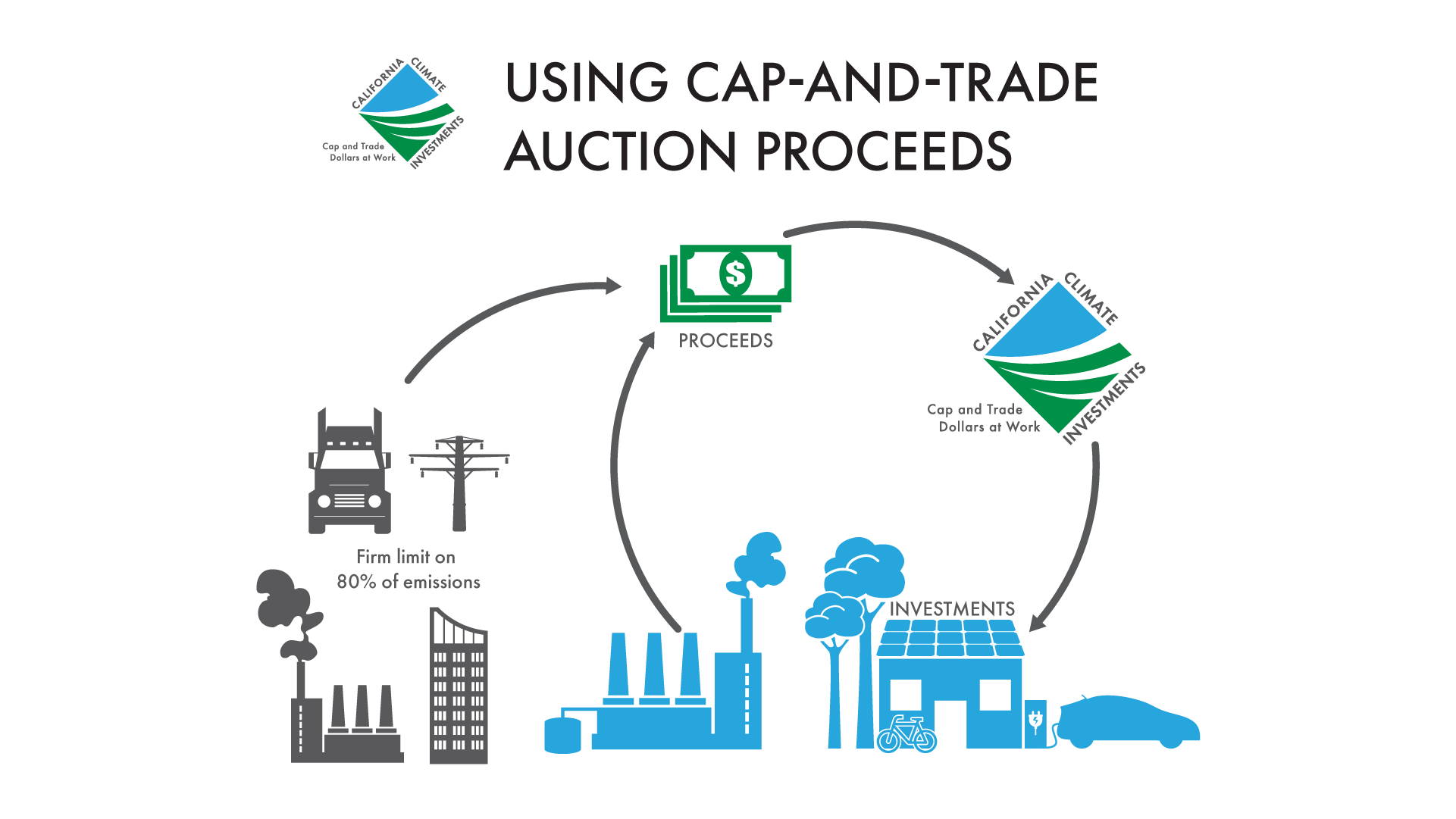
CARB Publishes Annual Report on California Climate Investments
CARB Publishes Annual Report on California Climate Investments as Governor Newsom and California Legislature Seek Extension of Cap-and-Trade Program
May 7, 2025 –
Annual Report on California Climate Investments:
The California Air Resources Board (CARB) published its annual report on California Climate Investments using Cap-and-Trade proceeds. According to the report, nearly $33 billion has been raised from Cap-and-Trade to fund climate solutions in communities across the state; of this amount, $12.8 billion projects have been implemented under 117 programs administered by 27 agencies. Along with the report, CARB released a general fact sheet documenting cumulative project achievements through November 2024 including $1.5 billion invested in wildfire prevention, forest health and prescribed burning activities and 1.6 million acres of land conserved or restored.
Extension of Cap-and-Trade Program:
Prior to the report’s publication, Governor Newsom, Senate President pro Tempore McGuire and Assembly Speaker Rivas announced they will seek an extension of the Cap-and-Trade Program during this legislative year. The program is currently set to expire in 2030 and requires extension by the Legislature. As the Governor noted in his proposed budget, extending the program this year can provide the market with greater certainty, attract stable investment, further California’s climate leadership and set the state on a clear path to achieve its 2045 carbon-neutrality goal.
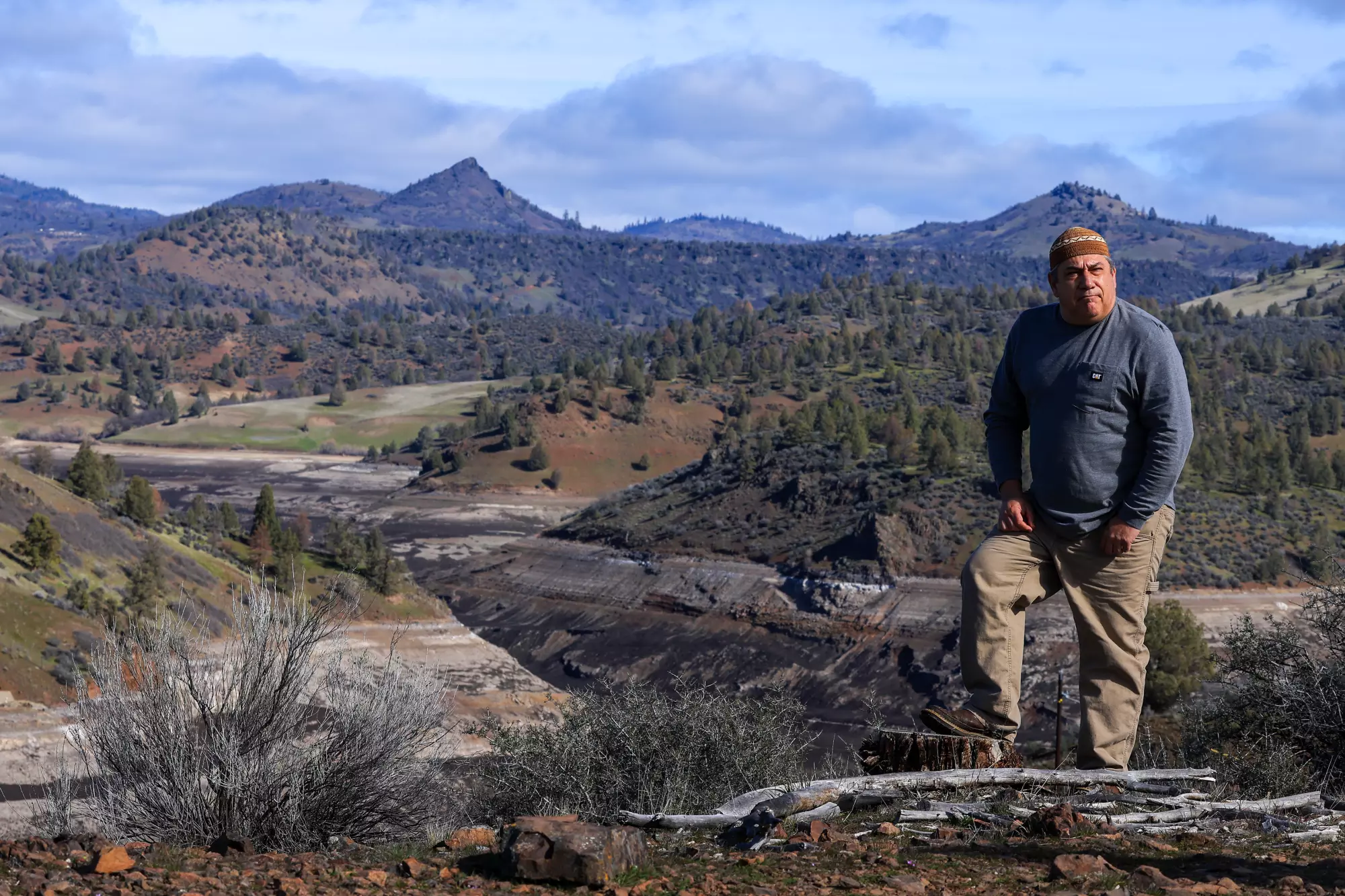
California Signs Cultural Burning Agreement with Karuk Tribe
California Advances Wildfire Resilience and Honors Tribal Sovereignty Through Cultural Burning Agreement with the Karuk Tribe
March 7, 2025 – The Karuk Tribe and the California Natural Resources Agency (CNRA) have entered into a historic agreement as part of CNRA and CalEPA’s announcement that SB 310 is now in effect. This legislation and agreement acknowledges tribal sovereignty and addresses historical injustices while contributing to the mitigation of catastrophic wildfire by enabling CNRA and local air districts to enter into agreements with federally recognized California Native American tribes to support them in conducting cultural burns in their ancestral territories. For more information, read the FAQ on SB 310.
CNRA will be hosting a webinar about the landmark cultural burn agreement with the Karuk Tribe and SB 310 on April 1, 2025 at 1pm.
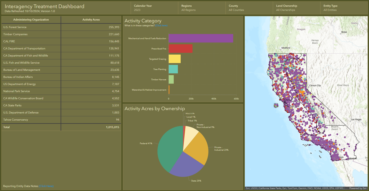
Interagency Treatment Dashboard Shows Progress Toward Resilience
FOR IMMEDIATE RELEASE
October 10, 2024
California Unveils First-of-Their-Kind Dashboards Mapping Out Fire-Prevention Work to Protect Communities
New tools created by CAL FIRE and Wildfire and Forest Resilience Task Force simplify data, boost transparency, and help inform wildfire planning and response – adding to the suite of tools the state has created
(South Lake Tahoe, CA) – The Governor’s Wildfire and Forest Resilience Task Force and the California Department of Forestry and Fire Protection (CAL FIRE) unveiled several new tools today to help California track and communicate the state’s significant progress in improving wildfire and landscape resilience.
Key takeaways from the Task Force’s Sierra Nevada Regional Meeting in South Lake Tahoe include:
• Interagency Treatment Dashboard updated to show 2021, 2022 and 2023 data.
• Over one million acres of treatments were conducted on about 700,000 footprint acres in 2023.
• Prescribed fire treatments more than doubled between 2021 and 2023.
• CAL FIRE Fuel Treatment Effectiveness Dashboard is showing the impact of treatments impacted by recent wildfires.
“Thousands of wildfire resilience projects have been completed across California to protect our communities and landscapes from catastrophic wildfire in recent years, and more are underway,” said Wade Crowfoot, Secretary of the California Natural Resources Agency and co-chair of the Task Force. “Thanks to historic investments from our state and federal leaders, dozens of local agencies and hundreds of organizations are delivering these projects. Now for the first time, we have a dashboard that tracks all these diverse projects in one place and on one map. This enables us to measure our overall progress toward building wildfire resilience across the state and provides regional leaders valuable information to plan future projects.”
Interagency Treatment Dashboard
The updated version of the Interagency Treatment Dashboard shows wildfire resilience work (or “treatments”) for three calendar years (2021, 2022 and 2023). The data, which was sourced from federal, state, local, tribal, and private entities, is now available in a single hub that allows Californians to easily see where treatments (such as prescribed fire, mechanical thinning, and tree planting) have been completed. This information is used to inform firefighting efforts, ensure transparency to the public, and track progress toward statewide goals.
The Task Force released a Beta version of the Dashboard last year with 2022 data. This updated version now includes data for 2021, revised data for 2022, and new data for 2023.
Over 1 million acres worth of treatment work on 700,000 acres of land
The Dashboard shows significant progress on multiple fronts to bolster wildfire resilience in California. In 2023, more than one million acres of treatments were conducted on about 700,000 acres, with many acres receiving multiple treatments such as thinning, prescribed fire, or other practices to improve forest health and community resilience. The Task Force is tracking both “activity acres” – which reflect the level of effort conducted through various state, federal, and private programs – and “footprint acres” – which show the total geographic area treated in a calendar year.
The 2023 data shows a significant increase in acres treated since 2021. The increase is largely due to a significant expansion of prescribed fire treatments, which more than doubled since 2021. These efforts have put the state on a solid path toward meeting its joint commitment with the U.S. Forest Service to complete treatments on more than a million acres by the end of 2025.
The Task Force is committed to increasing the pace and scale of statewide actions to address California’s wildfire crisis. The Dashboard is part of a larger strategy to connect the various statewide entities committed to this monumental task.
Fuel Treatment Effectiveness Dashboard
CAL FIRE also launched a Fuel Treatment Effectiveness Dashboard, which shows how wildfire prevention projects are helping protect communities and landscapes when wildfire strikes. “Utilizing technology, we can now track in real time when wildfires hit areas where fuel treatments have been conducted. We can then go into an area and see how those treatments affected fire behavior, evacuation routes, firefighting efforts and more,” said CAL FIRE Chief/Director Joe Tyler. “This new dashboard is a tool for the public to see how fuels treatments had a positive impact on the firefight and how this work is making a difference.”
“No other state in the country is tackling wildfire resilience at this scale or with this level of innovation,” added U.S. Forest Service Deputy Regional Forester Kara Chadwick, who co-chaired today’s meeting. “From groundbreaking prescribed fire projects to comprehensive data tracking systems, we’re setting the standard for what it means to protect our landscapes and communities.”
The meeting is supplemented by field tours on October 8 and 11, to showcase wildfire resilience projects in the Tahoe Basin. Tour highlights include recovery efforts following the 2021 Caldor Fire, long-term prescribed burn projects in Sugar Pine Point State Park, meadow restoration at Máyala Wát undertaken by the Washoe Tribe of Nevada and California, and the first new industrial-scale sawmill built in Sierra Nevada in several decades.
“Today’s meeting is a major milestone in our efforts to better document and share our collective progress,” said Task Force Director Patrick Wright. “We will continue to build on our collective momentum to make California more resilient to wildfire.”
The next Task Force meeting will take place in Sacramento on December 13 and will provide a synthesis of the latest scientific findings that are informing California’s approach to address wildfire risks in a changing climate. These findings will be incorporated into the Task Force’s 2025 Action Plan Update.
Sky Biblin, Communications Coordinator
Governor’s Wildfire and Forest Resilience Task Force
916-502-6527
New Web Resources Help Californians Find Relief from Smoke and Prepare for Wildfires
New Web Resources Help Californians Find Relief from Smoke and Prepare for Wildfires
June 24, 2024 – Clean Air Centers Maps Shows Where to Find Relief from Wildfire Smoke: The California Air Resources Board announced the launch of an interactive, statewide map that offers a one-stop-shop for information about the location and services available at Clean Air Centers. Clean Air Centers will offer Californians who don’t have access to adequate air filtration a safe place to go during periods of heavy smoke. Built in collaboration with local air quality control districts, the online map makes it possible to see where Clean Air Centers are located and provides easy-to-access information, including operating hours, contact information and on-site resources like free Wi-Fi.
CAL FIRE Updates Wildfire Preparedness Website: In preparation for the fire year, CAL FIRE has updated the ReadyForWildfire.org site. This one-stop-shop provides advice and guidance on everything from home hardening and defensible space, to what to pack for evacuation, to what California is doing to enhance and protect forest health.
New Online Treatment Dashboard to Track Wildfire Resilience Projects
New Online Treatment Dashboard to Track Wildfire Resilience Projects
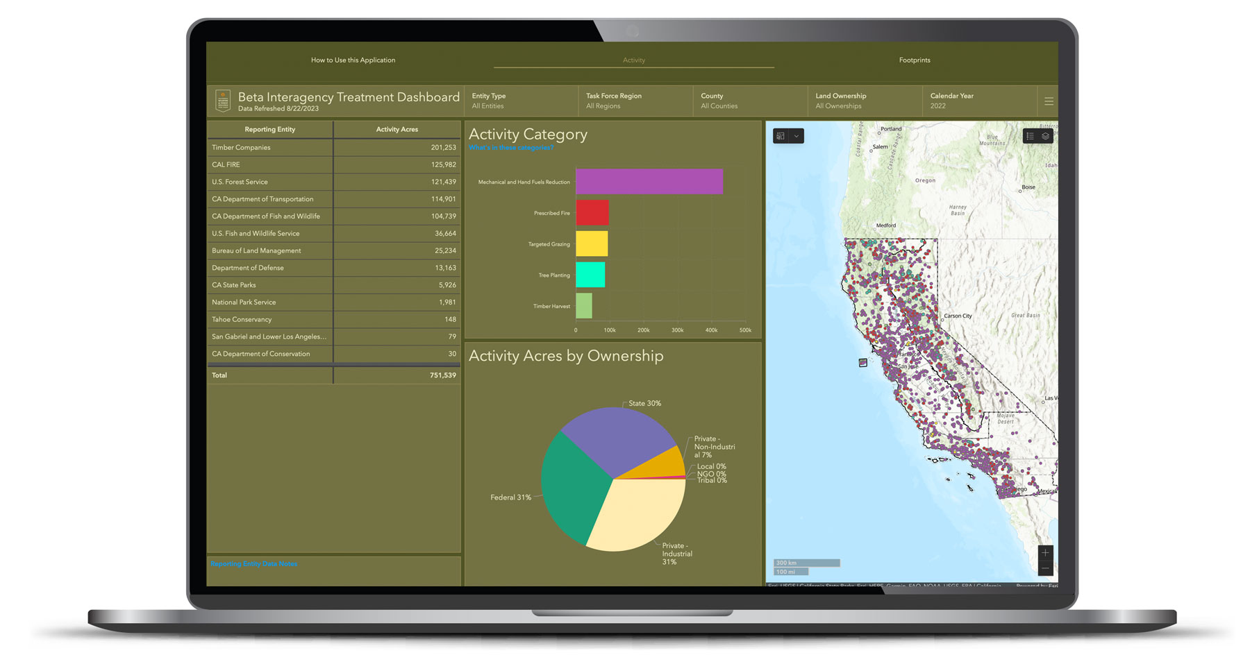
On August 29, the Governor’s Wildfire and Forest Resilience Task Force launched the beta version of a first-of-its-kind Interagency Treatment Dashboard beta that displays the size and location of state and federal forest and landscape resilience projects in California.
The dashboard offers a one-stop-shop to access data, provide transparency, and align the efforts of more than a dozen agencies to build resilient landscapes and communities in California. It reports treatment activities such as prescribed fire, targeted grazing, uneven-aged timber harvest, mechanical and hand fuels reduction, and tree planting. Users can sort treatments by region, county, land ownership and more.
The beta version of the dashboard will continue to be refined to include additional data, including projects by local and tribal entities, along with revisions based on public feedback. An official launch is expected in spring 2024 with more complete data on projects implemented in 2022.
California Launches Online Tool to Track Wildfire Resilience Projects
FOR IMMEDIATE RELEASE
August 29, 2023
California Launches Online Tool to Track Wildfire Resilience Projects
New beta statewide tracking system brings local, state, and federal wildfire resiliency projects into one place to reflect significant progress.
(Sacramento, CA) – Today, the Governor’s Wildfire and Forest Resilience Task Force (Task Force) launched the beta version of a first-of-its-kind Interagency Treatment Dashboard that displays the size and location of state and federal forest and landscape resilience projects in California.
The dashboard offers a one-stop-shop to access data, provide transparency, and align the efforts of more than a dozen agencies to build resilient landscapes and communities in California. It reports treatment activities such as prescribed fire, targeted grazing, uneven-aged timber harvest, mechanical and hand fuels reduction, and tree planting. Users can sort treatments by region, county, land ownership and more.
“Thanks to historic funding from our Legislature and Governor Newsom, over 1,000 wildfire resilience projects are in motion across the state to protect communities and our diverse landscapes from catastrophic wildfire,” said California Secretary for Natural Resources Wade Crowfoot, co-chair of the Task Force. “Now we can track our progress like never before through this public Interagency Dashboard. It identifies where projects are happening, what kind of work is happening in a given location, and how much overall resilience work is being done. It’s one more step forward in building a comprehensive, durable approach to increasing our wildfire resilience in years to come.”
“This dashboard delivers a new tool for collaboration among agencies and communities,” said U.S. Forest Service Regional Forester Jennifer Eberlien, who co-chairs the Task Force with Secretary Crowfoot. “Having access to treatment information in this format will allow us to coordinate landscape scale activities aimed at restoring and enhancing ecosystem resilience.”
The dashboard compiles data from a broad range of organizations and government departments—many of which have different reporting requirements guiding how they capture information. While individual reporting tools and data will sometimes differ from this statewide snapshot, the dashboard brings these different reporting approaches together as a single and streamlined reporting tool. Key differences are addressed in the dashboard website FAQs .
“It takes everyone to create a more wildfire resilient California and this dashboard reflects the strides being made to get us there,” said CAL FIRE Director and Fire Chief Joe Tyler. “This dashboard shows how far we’ve come, the significant efforts underway, and our firm commitment to future work. As our many partners share data and outcomes to a central place, the mission of protecting communities and natural resources will remain the common thread driving our work. This new tool will also provide first responders a snapshot of where treatment has occurred to help inform fire suppression efforts.”
The dashboard is an important step to increase the pace and scale of statewide actions addressing California’s wildfire crisis and is a key deliverable of the Governor’s Wildfire and Forest Resilience Action Plan , issued by the Task Force in January 2021.
The beta version of the dashboard will continue to be refined to include additional data, including projects by local and tribal entities, along with revisions based on public feedback. An official launch is expected in spring 2024 with more complete data on projects implemented in 2022.
Contact Information:
Sky Biblin, Communications Coordinator
Governor’s Wildfire and Forest Resilience Task Force
916-502-6527
Albert Lundeen, Director of Media Relations
California Natural Resources Agency
albert.lundeen@resources.ca.gov
916-606-3990
D’Artanyan Ratley, Public Affairs Specialist
USDA Forest Service
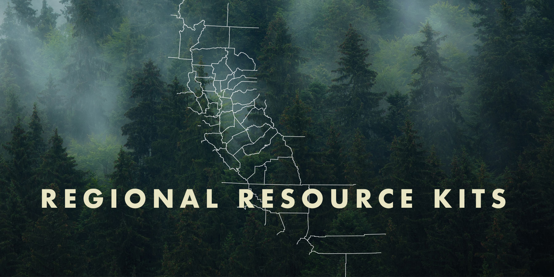
Regional Resource Kits and Profiles Are Now Available
Regional Resource Kits and Profiles Are Now Available
The Task Force’s Science Advisory Panel has completed Regional Resource Kits and Regional Profiles for both the Sierra Nevada and Southern California regions. These invaluable tools are now available here on the Task Force website.
Regional Resource Kits offer critical tools and data to guide regional partners and collaboratives in their efforts to reduce wildfire hazard and improve the conditions of forested and shrub landscapes.
Likewise, Regional Profiles bring together the best available scientific information and a wide range of input from stakeholders throughout the region.
The Science Team will now focus on collecting data and tools for the Central Coast in preparation for the May 2023 Task Force meeting.