
Prescribed Fire Monitoring and Reporting
Prescribed Fire Monitoring and Reporting
Department: California Air Resources Board (CARB)
Program Description: Successfully increasing prescribed fire must be supported with effective planning, smoke monitoring and reporting to assess health and climate impacts, as well as public education and outreach to secure awareness and support. Funding is included for the California Air Resources Board and local air districts for increased monitoring, permitting, and communication related to prescribed fire.
Program Impact: Air districts statewide have achieved documented increases in prescribed burn smoke monitoring, and in public notification and public education. Smoke monitors are cached at five locations across the state for air district use. The California Smoke Spotter mobile app received several upgrades in 2022 to improve the public burn and smoke notification platform, including more frequent refreshing of burn status and wildfire notifications added to existing information on individual prescribed burns. The State’s voluntary prescribed fire information reporting system (PFIRS) for smoke management is being upgraded in coordination with data system improvements at CAL FIRE and other agencies.
Resilience in Action: In the three years since inception of the CARB prescribed burn reporting and monitoring program, June 2019 to June 2022, the state’s air districts logged 9,449 reported prescribed burns, representing more than 366,000 total acres managed. Burns monitored statewide for air quality impacts totaled 987 over the same period, representing a 60 percent average year-over-year increase in burn monitoring from 2020 to 2022.
Program Website Links:
- California Air Resources Board launches California Smoke Spotter app | California Air Resources Board
- California Air Resources Board releases California Smoke Spotter 2.0 | California Air Resources Board
- Agricultural & Prescribed Burning | California Air Resources Board
- Smoke Management Programs and Burn Decisions – Other Air Districts | California Air Resources Board
Traditional Media Coverage:
- Los Angeles Times, Sept. 2022: Forest Service resumes prescribed fire program, but some fear new rules will delay projects
- Los Angeles Times, Aug. 2022: As forests go up in smoke, so will California’s climate plan
- TimeOut Los Angeles, Aug. 2022: This app can forecast how bad wildfire smoke will be near you
- KRCR-TV (Redding), July 2022: North Coast air quality officials urge residents to prepare for wildfire smoke risks
- Yuba Net, May 2021: Beale Fire Department, Wildland Support Module set to conduct prescribed burn
- San Francisco Chronicle, July 2021: The number of controlled burns is rising in Is it enough?
- ABC 10 in Sacramento, Jun 2021: New app tracks smoke in California
- Pew Charitable Trusts, September 2020: California May Need More Fire to Fix its Wildfire Problem
- North Bay Business Journal, August 2020: Lack of grazing, prescribed burns adds fuel to California’s wildfires, say experts and stakeholders
California Smoke Spotter 2.0 launch (August 2022):
- CARB releases Smoke Spotter 2.0
- #CASmokeSpotter‘s personalized alert settings can help you plan for possible smoke exposure
- The best way to protect yourself from smoke is to plan for it.
Since California Smoke Spotter was first launched in May 2021, and with the addition of wildfire smoke information and forecasting in August 2022, nearly 8,000 users have downloaded the app.
RESOURCES
State Demonstration Forests
State Demonstration Forests
Department: CAL FIRE
Program Description: The California Department of Forestry and Fire Protection (CAL FIRE) operates nine Demonstration State Forests totaling approximately 72,000 acres. The forests represent the most common forest types in the state.
These living laboratories focus on applied research and testing the best forest management practices for carbon sequestration, forest health and fire resilience. Demonstration forests provide answers to some of the most difficult forest management questions that we currently face under a rapidly changing climate, from stand-density to ecological co-benefits to better understanding forest hydrology.
With the ability to conduct decadal-long studies, the demonstration forests inform updates to the forest practice rules governing the 8 million acres of commercial timberlands in California. The forests also provide research and demonstration opportunities for natural resource management, along with recreation opportunities, fish and wildlife habitat, and watershed protection.
Program Impact: In addition to supporting operating costs, this $10 million investment is critical to help modernizing the mission of the demonstration forests. Activities will include:
- A carbon sequestration study
- Prescribed fire research
- Fuel reduction work to enable prescribed fires
- Upgrades to trails and recreational facilities
- Improved community communication programs
- Resources to support tribal co-management
Mountain Home: The 2020 and 2021 fire seasons killed an unprecedented number of monarch giant sequoias in California. However, the grove of old-growth Giant Sequoias at Mountain Home were protected from catastrophic loss during the 2020 Castle Fire due to a decade of active management, including timber harvest, fuel reduction, and prescribed burning. Funding supported removal and burning of post-fire woody debris to prepare approximately 400 acres for reforestation. 212,000 seedlings, including 25,000 giant sequoias were planted in 2022. Another 10,000 giant sequoia seedlings are being grown at the LA Moran Reforestation Center for planting in 2023 to complete post-fire reforestation efforts. Mountain Home Giant Sequoia Grove Post-Castle Fire (2020) statistics:
- 2022 Re-inventoried Giant Sequoia: 4,483
- Mortality: 335 (7.5 percent)
Jackson Demonstration State Forest: Understanding the role forests play in watersheds is crucial, especially during California’s ongoing mega drought. The Jackson Demonstration Forest has been conducting one of the most comprehensive forest hydrology studies in the nation with data going back to 1962. CAL FIRE just executed a 100-year Memorandum of Understanding with the US Forest Service Pacific Southwest Research Station to continue the Caspar Creek Watershed Experiment. The third experimental harvest in this study occurred in 2018. Specific plots were harvested at different densities to track the water yield relative to the forest density. The 2018 harvest is starting to yield preliminary results on the influence of forest stand density reduction on watershed function and yield. This is critical to understanding how forests can help protect watershed and mitigate drought conditions.
Advancing Scientific Understanding of Forests, Fire, and Climate Change: The following scientific studies are being undertaken on Demonstration State Forests to contribute to our knowledge of forests as a nature-based solution to climate change and demonstrate resilient forest landscape conditions to private landowners.
- Adaptive Management Experiment for Coastal Redwoods: Led by Dr. Sarah Bisbing, University of Nevada Reno, this study will develop three foundational silvicultural treatments to prepare forests for disturbance events exacerbated by a changing climate. Resilience treatments will facilitate recovery of pre-disturbance forest structure. Resistance treatments will allow for the recovery of ecological functions of a forest though the structure and composition may change. Transition treatments will help forests adapt to a changing climate when the forest cannot recover without active intervention. This replicates an ongoing study in the Sierra Nevada forests.
- Potential Elite Tree Identification: Led by Dr. Stephen Sillett, Cal Poly Humboldt, this study will help us understand traits of individual redwood trees in managed forests with the greatest capacity for carbon sequestration and long-term carbon storage.
- Mitigating Wildfire Hazard in the Redwoods: Led by Dr. Pascal Berrill, Cal Poly Humboldt, this study will evaluate the effectiveness and tradeoffs of six common fuel treatments in coastal redwood forests. This funding will facilitate the pre-treatment of approximately 300 acres with mastication and hand crews prior to the reintroduction of prescribed fire. This will contribute to the knowledge of the safe and effective reintroduction of fire into coast redwood forests.
- Cultural Burning for Tanoak Improvement: This study is being conducted in coordination with a local Native American Tribe in Mendocino County to reduce the incidence of acorn weevils and improve acorn production within a coastal redwood forest.

Interagency Forest Data Hub
Interagency Forest Data Hub
Department: CAL FIRE
Program Description: The Hub will expand data sharing and require annual reporting, including acres treated, in a common data repository. These coordinated information products would be rapidly and reliably made available to land managers and decision-makers. CAL FIRE is entering into a 3-year research grant agreement with the Climate and Wildfire Institute (CWI) to develop a Phase 1 Forest Data Hub. The priority for Phase 1 of the Forest Data Hub is to meet the information needs of the Million Acre Strategy.
Program Impact: The development and sustainment of the Hub will help ensure interagency assets are centrally accessible to all government scientists and land managers, university researchers, NGOs, and other users across the state, to ensure policy makers and land managers are using the most up-to-date data and analytics to inform policy, planning, monitoring, and reporting. Phase 1 of the Forest Data Hub will provide functionality to directly support the Million Acre Strategy and in doing so will address complex issues related to data sharing models, data governance, and security issues.
The key components of the Phase 1 Forest Data Hub include:
- Treatment tracking of fuel reduction and other vegetation management projects across State, Federal, and local entities
- Dashboards that provide for reporting status of metrics/indicators
- Support and access to data sets in the Regional Resource Kits
- Improved access to data analytics, planning applications and data visualization tools (i.e. Planscape, Pyrologix, etc.)
- Access to existing forest resources data sets that support the Million Acre Strategy
The Hub may host new and emerging technologies designed to inform forest management practices at multiple scales tied to the Regional Forest and Fires Capacity Program.
Resilience in Action: The Hub is developing an interagency forest treatment tracking system, which will capture projects funded through the State’s wildfire resilience funding as well as federal and state partners. This fulfils one of the key actions of the Forest and Wildfire Resilience Action Plan. The Phase 1 of the Forest Data Hub will provide support for regional planning to expand the pace and scale of fuel reduction projects and related vegetation management projects.
RESOURCES
Remote Sensing
Remote Sensing
Department: CNRA
Program Description: CNRA is investing in high resolution data and analytical products for public safety and to protect ecosystems. Developing reliable base data such as remote sensing like LiDAR will improve predictivemodeling, project planning analytics, and long-term monitoring.
Program Impact: In addition to nearly $8 million dedicated to new LiDAR data collections across California , the remainder of CNRA’s Remote Sensing Portfolio (nearly $17 million) will deliver new remote sensing acquisitions, processed data products and analytics for application, including:
- Establishment of the first remote sensing flux tower network in the California. This will collect data on water and carbon dynamics necessary to calibrate satellite- based data products and inform forest health, carbon, and management assessments.
- Production of forest structure and individual tree information using high resolution data for applications including forest, post-fire, carbon, and biodiversity assessments to inform management interventions and fire and fuels mapping updates.
- Statewide Vegetation Change Detection System to remotely detect disturbances in fire-prone areas of California. This will help identify impacts from fire, tree mortality and timber harvest and inform evaluations of forest cover loss and recovery. This will help determine where quick intervention is needed to prevent forest canopy loss and prevent native shrublands from converting to invasive grasses.
- Statewide Wildfire and Forest Resilience Evaluation System blending field-based and remotely sensed data including water, biodiversity, forest, and carbon to spatially assess and quantify wildfire and forest ecosystem response to management including fuel reduction and forest health treatments. This will be a critical piece of an effective monitoring system.
- Collect and process on-demand, remotely-sensed data and imagery to provide timely public safety information critical for assessing post-wildfire geologic and hydrologic hazards on state and federal responsibility areas.
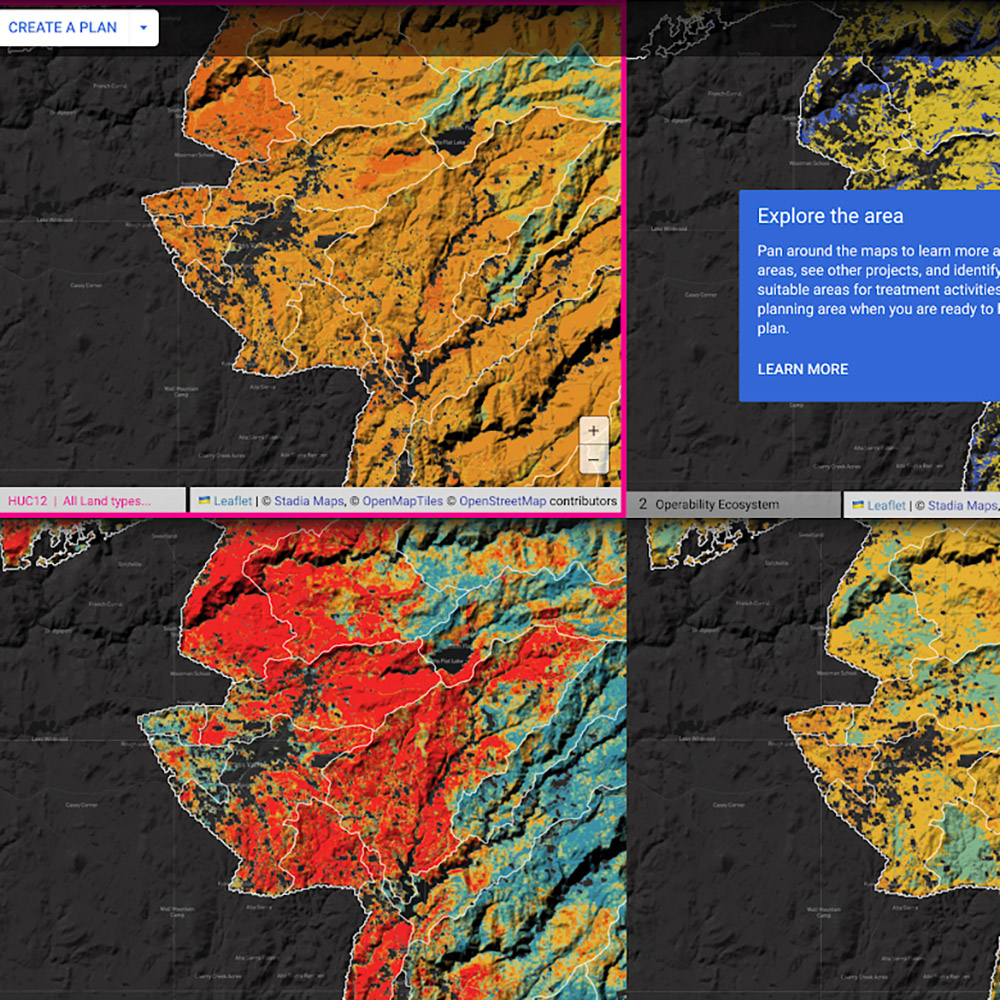
- Establish a wildfire resilience planning tool, called Planscape, which will help the wide array of wildfire resilience practitioners have the latest science and modeling at their fingertips as they design fuel breaks and forest health projects.
Resilience in Action:
LiDAR: In partnership with the USGS matching grants, California has already collected nearly 30 million acres of new LiDAR data throughout the Sierra Nevada and northern California. This fills in gaps and ensures that nearly every high fire risk region of the State has current LiDAR which will enable a detailed and updated understandingof the major fire impacts and risks across California’s critical fire-prone watersheds.
Planscape: In a public-private partnership with Google.org and the California Natural Resources Agency, the team has developed Planscape, a decision-support tool that makes it easier for planners to design wildfire resilience projects with additional environmental benefits, like biodiversity, carbon storage or even future climate modeling. The program uses State and federal data layers (like LiDAR) and models and developed an interactive user interface so the science interments from the State are easily accessible and usable to planners. Given the wide array of organizations implementing California’s $2.7B wildfire resilience program, Planscape will make it easier for State, Federal, Tribal and local foresters and environmental scientists to have consistent science and models at their fingertips when designing their projects. This will enable more precise targeting and program design. The tool is anticipated to be publicly available in late 2023.
RESOURCES
Research and Monitoring Program (FRAP)
Research and Monitoring Program (FRAP)
Department: CAL FIRE
Program Description: CAL FIRE (FRAP) implements a Research and Monitoring program that supports:
- Forest Inventory & Analysis (FIA) Program Intensification – re-measurement of California forests in half the normal time (i.e. moving from a 10yr to a 5yr re-measurement cycle)
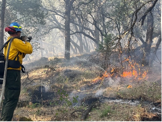
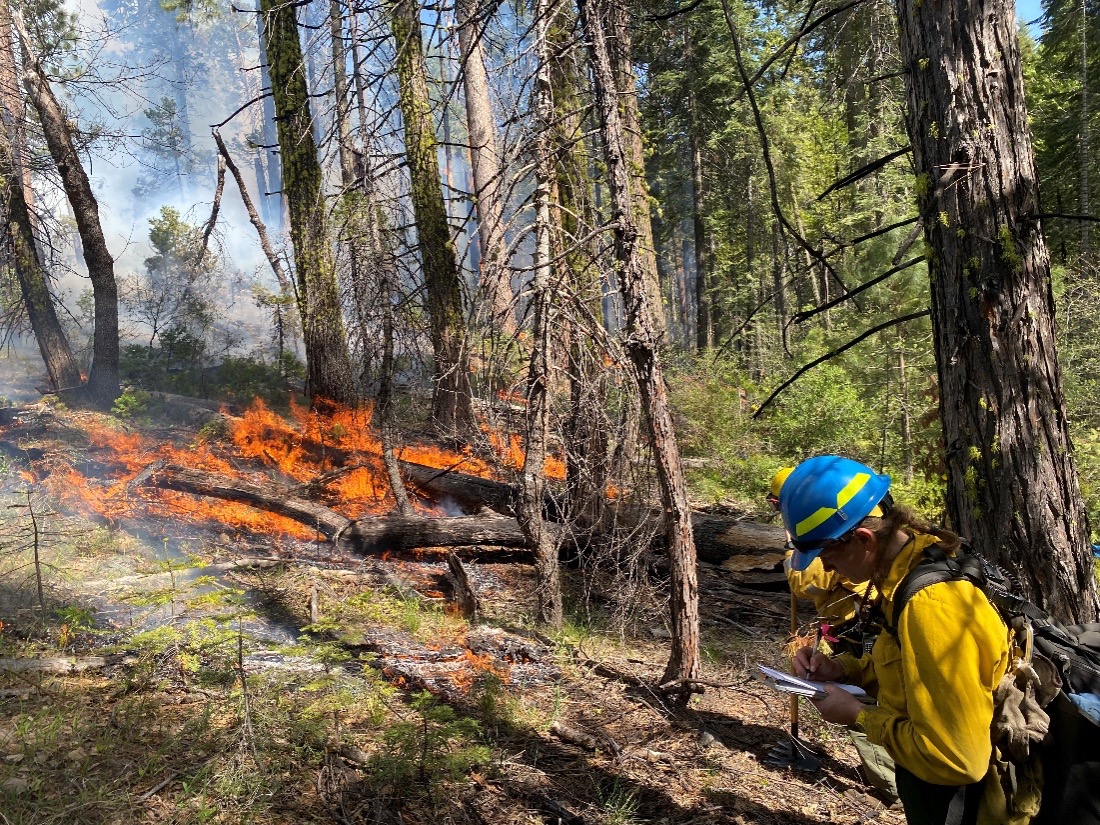
- Increased prescribed fire monitoring to better understand effectiveness of expanded use of prescribed fire
- Collaborative research in wildfire and forest health issues
- Forest Health Research grants
Program Impact: A network of thousands of forest measurement plots throughout California represent California’s portion of the national Forest Inventory & Analysis program. These plots are typically re-measured every decade for specific ecological indicators, creating a measured dataset that informs the State’s understanding of biodiversity, forest growth rates, carbon storage, and climate risks. Given the speed of climate change and stressors, this funding is enabling CAL FIRE to measure these plots every five years, rather than ten, to ensure decisions are being made on the most current ecological realities. Funding established two FIA Coordinator positions that will expand CAL FIRE’s capacity to implement FIA Intensification and to report on forest health trends.
- FIA data is a primary dataset informing annual reports to the Board of Forestry, and portions of the California Forest and Rangeland Assessment published every 5-years
- FIA data is a primary dataset informing the Pacific Coast Region Temperate Forest Carbon Stocks and Flux: 2001-2019, a regional forest carbon assessment of British Columbia, California, Oregon, and Washington (currently in draft)
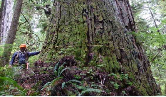
FIA plot sampling measuring diameter at breast height of a redwood in Del Norte County
Prescribed fire monitoring Big Trees State Park
Funding for prescribed fire monitoring supports multiple and complementary university contracts (UC Davis, Chico State, San Jose State). This allows for increased capacity to conduct monitoring across a variety of vegetation types and provides an opportunity to support a broader diversity of students.
Wildfire resilience investments allowed the Forest Health Research Program to fund roughly a third of the competitive grant proposals submitted. The program received research proposals totaling $22 million in the last grant solicitation, including $1.5 million for three new projects on CAL FIRE Demonstration State Forests.
Resilience in Action: Examples of funded and ongoing monitoring and research studies include:
- Sierra Nevada Adaptive Management Experiment, funded by CAL FIRE, with new expanded project site in Jackson Demonstration State Forest starting in 2023
- “An open source platform for tracking carbon uptake and storage across California forests” – Dr. Troy Magney, University of California Davis
- “Forecasting the impacts of climate change, land use change, and management on wildfire risk and downstream impacts in Southern California’s montane forests and surrounding shrublands” Dr. Alexandra Syphard, Conservation Biology Institute
- “Understanding the costs and limits of vegetation management for wildfire mitigation in coastal California: a comprehensive ecological and economic study at the Soquel Demonstration State Forest” – Dr. Richard Cobb, Cal Poly San Luis Obispo
- Boggs Mountain Demonstration State Forest Post-fire Revegetation Study – Dave Sapsis, CAL FIRE (CAL FIRE video on YouTube)
- News coverage on the GigaFire Fuels Mapping Project, jointly funded by CAL FIRE and CARB
- Forest Health Research Program webinar: “Climate change and wildfires in western North American forests: a review of ecological departures and adaptation strategies” Dr. Susan Prichard and Dr. Keala Hagmann, University of Washington