
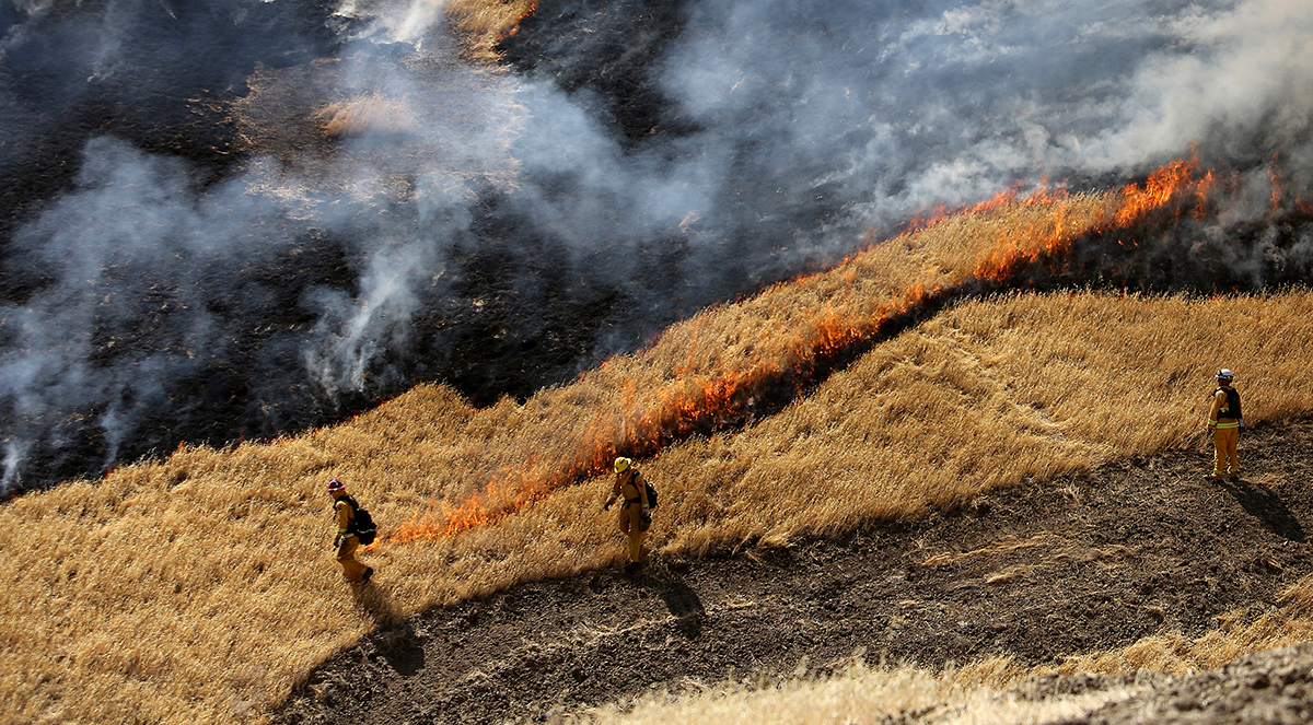
CAL FIRE Exceeds Goal of 100,000 Acres Treated Ahead of Schedule
CAL FIRE Exceeds Goal of 100,000 Acres Treated Ahead of Schedule
Transition to peak staffing for upcoming fire season also complete.
June 21, 2022 – CAL FIRE is making significant progress in their important contributions to California’s Wildfire and Forest Resilience Action Plan. Today they announced two significant accomplishments, starting with the news that they have already surpassed one of the plan’s Key Action items – to treat 100,000 acres by 2025.
According to current estimates, CAL FIRE has achieved 110,925 acres treated by using all fuels reduction methods, including prescribed fire. The work includes more than 600 fuel reduction projects.
Along with achieving this important milestone, in preparation for the upcoming wildfire season, CAL FIRE has also completed the transition to peak staffing across California. Peak staffing ensures all CAL FIRE stations are open and staffed 24 hours per day; response capabilities are enhanced; all aircraft are prepositioned and staffed; and crews are staffed, trained, and working.
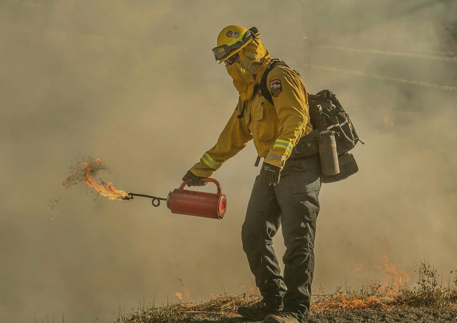
Recent CAL FIRE Grants Total Over $250M For Wildfire and Forest Resilience
Recent CAL FIRE Grants Total Over $250M For Wildfire and Forest Resilience
Funded projects address threatened communities, forest health, prescribed fire, restoring burned landscapes and more.
June 2, 2022 – CAL FIRE Grant Programs have allocated funds to address crucial needs in a wide range of areas related to wildfire and forest resilience. Together, they represent significant progress towards achieving the goals of California’s Wildfire & Forest Resilience Action Plan.
$118 million in funding was awarded for 144 Wildfire Prevention projects across the state. CAL FIRE’s Wildfire Prevention Grants enable local organizations like fire safe councils, to implement activities that address the hazards of wildfire and reduce wildfire risk to communities. Funded activities include hazardous fuel reduction, wildfire prevention planning, and wildfire prevention education.
CAL FIRE’s Forest Health Program awarded 22 grants totaling $98.4 million for landscape-scale forest health and prescribed fire projects spanning over 55,000 acres and 14 counties. They also awarded $10 million to the North Coast Resource Partnership (NCRP) for its regional wildfire resilience plan, which was developed with support from the Department of Conservation’s Regional Forest and Fire Capacity Program.
30 grants totaling $33 million came from CAL FIRE’s Wood Products and Bioenergy Team for business and workforce development projects. Ten workforce grants will help train over 5,000 individuals in prescribed fire, fuels treatment, firefighting, and forestry, and another14 grants will create 120 jobs and utilize 750,000 tons of forest biomass that would otherwise remain in the woods or be burned in open piles. Two projects will expand the State’s native tree seed bank and grow seedlings to assist with reforestation, and six research and development grants will fund novel uses for forest biomass sourced from wildfire mitigation projects.
CAL FIRE’s Wildfire Resilience Program awarded $9.99 million in block grants to the American Forest Foundation (AFF), Tahoe Truckee Community Foundation, and the California Association of Resource Conservation Districts (CARCD). The grants will support forest improvement projects on approximately 6,000 acres of small non-industrial private forestlands and provide technical assistance to private landowners in13 counties.
Roadmap to a Milllion Acres
Roadmap to a Million Acres
OVERVIEW
The Wildfire and Forest Resilience (WFR) Task Force is developing a comprehensive strategy, the Roadmap to a Million Acres (Figure 1), to scale up our collective efforts to treat a minimum of one million acres annually by 2025. As shown below, the Roadmap includes three key elements: 1) state-wide interagency strategies that align the work of federal, state, local, and tribal governments; 2) an interagency tracking system and Forest Data Hub to provide consistent data systems to track progress and assess the condition of our landscapes; and 3) a regional framework for investing in programs and projects tailored to the priorities and risks in each region.
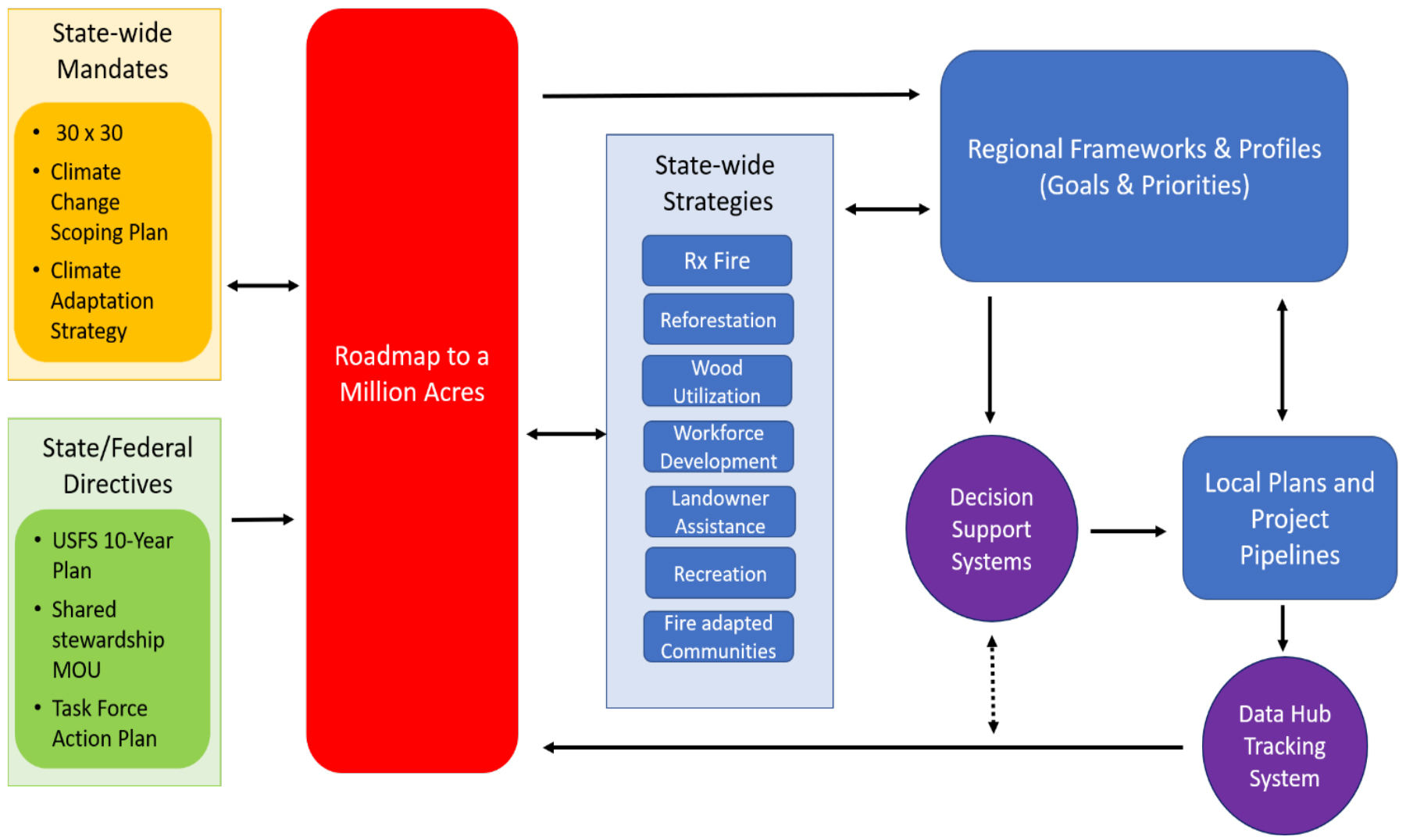
1. STATE-WIDE INTERAGENCY STRATEGIES
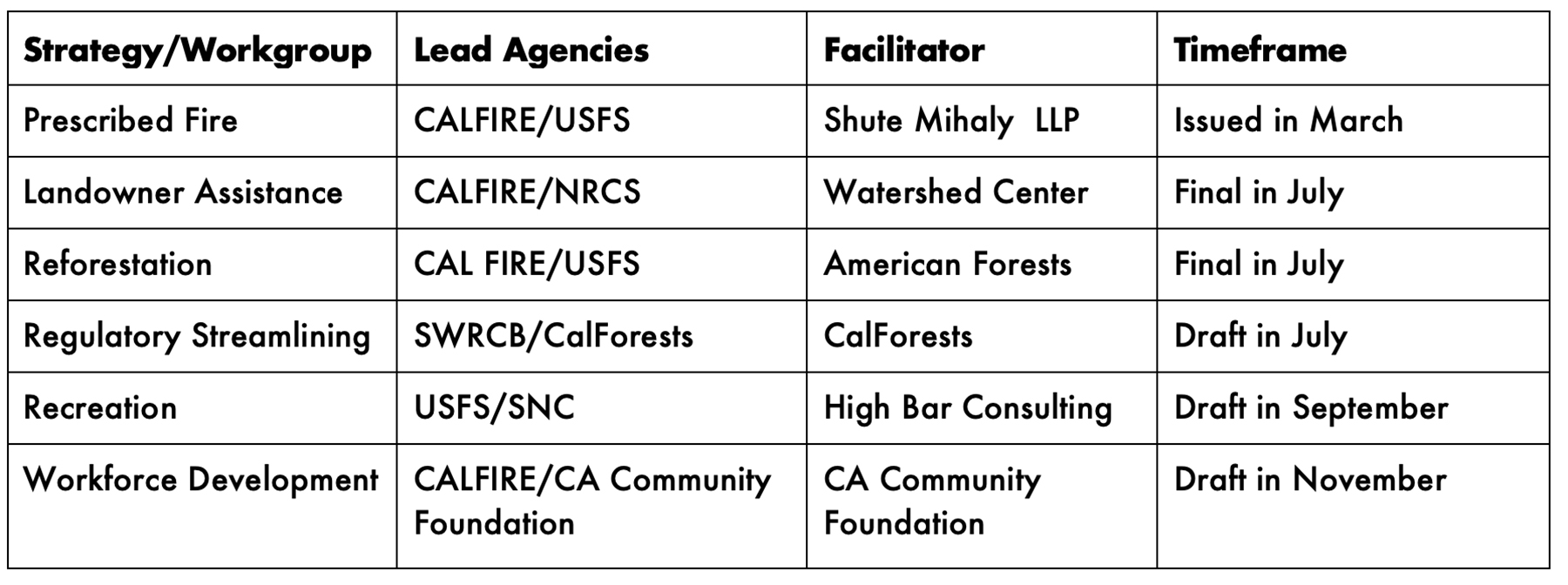
These state-wide strategies set aggressive but achievable targets for a broad range of interagency programs, from prescribed fire to reforestation and private landowner assistance. They also focus on reducing logistical barriers, addressing policy issues, and aligning federal, state, and local efforts — functions essential to meeting the annual million-acre goal. As shown below, these strategies will be largely completed by the end of 2022.
2. DEPLOYMENT OF DATA AND ANALYTICS
To provide common measures of progress and consistent information for planning and tracking, the Task Force is developing three linked information services: an interagency tracking system of recently completed and planned projects state-wide, a common set of metrics to define and measure forest and wildland resilience, and a Forest Data Hub that functions as a clearinghouse for data and reporting systems.
Interagency Tracking System: This system will include both summary information on statewide activity to measure progress towards the million-acre target, and a spatial “dashboard” of treatments that will help land managers and others align federal, state, local, tribal, and private projects throughout the state. The system will be built in stages, with an initial focus on compiling data from larger state, federal, and private reporting systems, and later phases capturing all projects through a mobile app-based system. The Task Force will report on its initial findings at the July 2022 meeting.
Metrics and Assessments: The Task Force is working to align a broad range of agency efforts to define forest and wildland resilience. This alignment will assist local and regional collaboratives in setting priorities and measuring performance beyond acres treated. Alignment of restoration efforts revolves, in part, around collaboration in the development and interpretation of relevant spatial data that quantify a large array of landscape characteristics and conditions. Key components of this work include:
● Framework for Resilience: CalFire and the USFS, in coordination with the UC Berkeley Center for Law, Energy, and Environment (CLEE), are leading the development of a comprehensive set of measurable indicators of forest and wildland resilience. Originally developed as part of the Tahoe-Central Sierra Initiative, these include a draft set of ten “pillars” or objectives, including forest resilience, fire-adapted communities, biodiversity conservation, carbon sequestration, water security, air quality, wetland integrity, economic health and diversity, and social and cultural well-being (Framework for Resilience).
● Metrics: The agencies are also developing a comprehensive set of metrics to provide a common method for measuring and assessing landscape conditions and to enable progress towards the pillars of resilience. Examples of common metrics that can be tracked over time for example: probability of fire severity, at-risk infrastructure, tree mortality, carbon storage, runoff production, disturbance intensity, and species richness.
● Assessment of Forest Conditions: An interagency team, in partnership with the Center for Ecosystem Climate Solutions (CECS), is developing a series of regional assessments of forest condition. These assessments will evaluate conditions with respect to each pillar of resilience. Pillars will be quantified using a vetted set of common metrics. These metrics will include measures of landscape condition gathered from a variety of sources. For example, many of the vegetation structure and composition metrics will come from the F3 product (U.S. Forest Service Region 5 Remote Sensing Lab), which relies on both field and remote sensing data to extrapolate the details of Forest Inventory and Analysis (FIA) plots to a spatially contiguous landscape. The ACCEL project will be deriving a range of additional metrics based on the F3 data products, such as wildlife species richness and forest heterogeneity. CECS will contribute additional metrics based on their remote-sensing-informed, ecosystem process model. Importantly, CECS products are spatially and temporally compatible with the F3 data layers. Additional metrics are being generated by State programs, such as measures of the probability of fire severity. All data used in these assessments will be open-sourced and publicly available. Information for each pillar will include both the current condition, as well as the difference between the current state and a collectively defined target condition that represents a resilient state. These assessments will be visualized as a series of “heat maps”, i.e. spatially explicit values that indicate departure of current conditions from a target condition, for each pillar across the region of interest.
Integration with Decision-Support Systems: Forest collaboratives and regional partnerships are using a variety of public and private systems to inform the project prioritization process and develop landscape-scale strategies. The Task Force and its partner agencies will continue to support these diverse efforts but will also seek to ensure they are linked to the assessments and a common set of metrics described above. This approach will provide flexibility for regional partnerships to choose their own decision-support tools while ensuring that the Task Force and its partner agencies have a consistent yardstick for measuring progress at the regional and state-wide levels.
Forest Data Hub: The Task Force Monitoring, Reporting, and Assessment workgroup, in coordination with the Climate and Wildfire Institute (CWI), is overseeing the development of a Forest Data Hub to support the critical data needs associated with planning, implementing, and tracking state-wide forest management and conservation goals. The Data Hub will include:
● The interagency accounting system of completed and planned treatments by landowner, region and subregion throughout the state;
● A repository of scenario planning and data management efforts (e.g., the Air Resources Board Scoping Plan Update, the CA Fifth Climate Change Assessment, Pathway to 30×30);
● A federated data system that integrates a broad range of agency, academic, and local databases (e.g., zoning, building restrictions, impaired waterbodies); and
● An online data server that provides rapid and reliable access to the data and other scientific information needed by land managers and decision-makers.
3. REGIONAL CAPACITY
As described in the Wildfire and Forest Resilience Action Plan, the Task Force will seek to expand and strengthen the growing network of regional collaboratives and partnerships to help build the state’s capacity to treat at least a million acres annually. As described above, the Task Force will develop a common framework to assess landscape conditions, identify priority areas, measure progress, and accelerate the work of local and regional partnerships while enabling each region to address its own risks and priorities through landscape scale strategies. As shown in Figure 2, the Task Force will help coordinate these capacity building efforts at multiple scales across the state.
Regional Profiles: The Science Advisory Panel will develop a series of Regional Profiles that summarize the risks, interdependencies, and opportunities in achieving resilient forests, chaparral, and community protection. These profiles will provide scientifically robust, region-specific context to inform decision-makers, stakeholders, and the public on the key priorities and issues in each region.
Regional Resource Kits: The Task Force will work with its regional partners to develop a series of Regional Resource Kits to jumpstart capacity and accelerate implementation in each region. Beginning with the Sierra Nevada region on September 27th, the Task Force will present the first of these resource kits. At each of the subsequent regional meetings of the Task Force the remaining three Regional Resource Kits will be released. These resource kits will be jointly produced by the same interagency and academic team synthesizing core metrics and assessments (see Metrics and Assessment sections above). Each kit will include the following:
● Metrics: A core set of metrics used to quantify the pillars augmented by regionally specific information.
● Pillars: A common-language description of each pillar along with a workflow used to quantify each pillar.
● Regional Priorities and Management Opportunities: An integrated package of mapped products that includes the condition assessments by pillar (i.e., “heat maps”), recently completed and planned treatments, collaborative boundaries, critical infrastructure and other contextual map data (e.g., building footprints, transportation routes, and sensitive species habitats). Collectively, these maps can be explored to identify areas where investments are being made and find additional areas that would greatly benefit from investments.
● Regional Demonstrations: Case studies that demonstrate how available data, metrics and analytics (i.e., the Regional Resource Kit) can be used to help local and regional planning efforts (e.g., the landscape-scale strategy developed by the SERAL project and subregional strategy developed by the Tahoe Central Sierra Initiative in the Sierra Nevada).These demonstrations are aimed at illustrating some of the analytical approaches and decision support that are possible with the data and tools available to local planning efforts.
Regional Landscape Investment Program: The Task Force will develop an interagency landscape investment program that leverages federal, state, and local funding to support development and implementation of Regional Priority Plans (RPPs). These RPPs will be focused on developing pipelines of projects and 5- to10-year programs of work to provide the sustained levels of funding and capacity building necessary to increase the pace and scale of forest and wildland health treatments.
The initial focus will be on aligning USFS, CAL FIRE, state conservancy funding, but will be broadened over time to include other agencies. For example, the Wildlife Conservation Board (WCB), Department of Fish and Wildlife (DFW), Department of Water Resources (DWR), and other agencies could provide funding to RPPs that address their mandates and priorities at a landscape scale. This approach will enable regions to attract funding from several agencies and help facilitate alignment and integration of state and federal mandates at the regional level.
The Sierra Nevada Conservancy, in coordination with the USFS and other federal, state, and local agencies, will lead the development of a regional investment strategy for the Sierra Nevada region at the September Task Force meeting, and others will be developed for each of the subsequent quarterly regional meetings.The proposed approach will include the following key elements:
1. Identify Priority Areas: In each of the four major regions of the state, the Task Force partner agencies will identify priority areas for investments based on the findings of the science team and an assessment of the capacity of regional partnerships. These are likely to include areas now developing Regional Priority Plans through RFFC or SNC funding, and areas developing similar plans under related programs, such as the USFS Collaborative Forest Landscape Restoration Program (CFLRP).
2. Award Landscape Grants:
• In priority areas with completed RPPs, CAL FIRE, the USFS (through NFWF), and the conservancies will jointly provide grants of $10 million or more over 5-10 years.
• To be eligible for these grants, RPPs must meet the criteria established by the state’s Regional Fire and Forest Capacity (RFFC) Program, and by the requirements tied to each source of funding.
• To date, regional partnerships receiving landscape grants consistent with this approach include the North Yuba Forest Partnership (USFS: $m) , Stanislaus National Forest (USFS: $m), Dinkey Collaborative Forest Landscape Restoration Project (Sierra National Forest)(USFS: $m), and the North Coast Regional Partnership (CAL FIRE: $10 million).
3. Establish NEPA/CEQA Teams:
• The National Fish and Wildlife Foundation (NFWF), in partnership with the state’s RFFC Program, will establish interdisciplinary teams for each of the partnerships awarded landscape grants to accelerate the environmental review processes and permitting of their priority projects.
• More…
4. Award Planning/Capacity Building Grants:
• In other priority areas, the Department of Conservation, in partnership with the USFS (through NFWF) and the conservancies, will continue to fund the development of RPPs to build a pipeline of projects at a landscape scale.
• Consistent with the draft guidelines issued by the Department of Conservation, RPPs should be focused on the key priorities and risks in their respective areas, but must also include the following common elements:
• Geography and Governance: RPPs must address the unique geographic, biophysical, and social characteristics of their region and the governance structure necessary to effectively develop and implement the plan with broad-based support.
• Assessment and Methodology: RPPs must include an assessment of landscape condition, a methodology for decision making, and a program for evaluation of ongoing activities that are consistent with the metrics and assessments developed by the Task Force interagency science team.
•Landscape Portfolios of Projects: RPPs must include lists of priority projects that, taken together, respond to landscape scale wildfire and ecosystem health priorities.
•The following areas are currently developing Regional Priority Plans:
• North: North Coast Regional Partnership, Tehama, Napa
• Sierra Nevada:
• Central:
• South: Santa Monica, Inland Empire, and San Diego
Governor Update June 22

TASK FORCE HIGHLIGHTS
May 5 Task Force Meeting Highlights:
In partnership with the North Coast Regional Partnership, the Task Force held its first in-person meeting in Santa Rosa. The agenda included presentations from regional leaders about wildfire and forest resilience efforts in northern California. Watch the meeting!
Website Launch:
The Task Force is excited to announce that our new website is live at WildfireTaskForce.org. The site is a dynamic, content-rich source on activities of the Task Force and its workgroups, our progress in implementing the Wildfire and Forest Resilience Action Plan and will include highlights and videos of projects and programs that are improving landscape health and community resilience throughout the state.
State HIGHLIGHTS
Crescent Mills Sawmill Ribbon Cutting:
On May 18, Sierra Institute Director Jonathan Kusel joined with CNRA Secretary Wade Crowfoot, Sierra Nevada Conservancy (SNC) Executive Officer Angela Avery, and well over a hundred local leaders and participants to celebrate the opening of the new Crescent Mills sawmill in Plumas County. Funded by a $360,000 SNC grant, the mill and larger wood utilization campus will help rebuild the community of Greenville and others nearly destroyed by the Dixie Fire in 2021. The sawmill was featured in this NBC News Live feature on rebuilding Greenville and the related efforts by the USFS and Placerville Nursery to reforest after wildfire.
Grant Awards
· CAL FIRE awarded $118 million in funding for 144 Wildfire Prevention projects across the state. CAL FIRE’s Wildfire Prevention Grants enable local organizations like fire safe councils, to implement activities that address the hazards of wildfire and reduce wildfire risk to communities. Funded activities include hazardous fuel reduction, wildfire prevention planning, and wildfire prevention education.
· CAL FIRE’s Forest Health Program awarded 22 grants totaling $98.4 million for landscape-scale forest health and prescribed fire projects spanning over 55,000 acres and 14 counties. CAL FIRE also awarded $10 million to the North Coast Resource Partnership (NCRP) for its regional wildfire resilience plan, which was developed with support from the Department of Conservation’s Regional Forest and Fire Capacity Program.
· CAL FIRE’s Wood Products and Bioenergy Team awarded 30 grants totaling $33 million for business and workforce development projects. Ten workforce grants will help train over 5,000 individuals in prescribed fire, fuels treatment, firefighting, and forestry, and another14 grants will create 120 jobs and utilize 750,000 tons of forest biomass that would otherwise remain in the woods or be burned in open piles. Two projects will expand the State’s native tree seed bank and grow seedlings to assist with reforestation, and six research and development grants will fund novel uses for forest biomass sourced from wildfire mitigation projects.
· CAL FIRE’s Wildfire Resilience Program awarded $9.99 million in block grants to the American Forest Foundation (AFF), Tahoe Truckee Community Foundation, and the California Association of Resource Conservation Districts (CARCD). The grants will support forest improvement projects on approximately 6,000 acres of small non-industrial private forestlands and provide technical assistance to private landowners in13 counties.
RFFC Grant Guidelines:
The Department of Conservation (DOC) released the 2022 Regional Forest and Fire Capacity (RFFC) Program Draft Grant Guidelines to help build the capacity of forest collaboratives and regional partnerships to develop priority plans to improve the health and resilience of landscapes and communities. DOC will be accepting comments until June 23 and plans to issue the final guidelines on June 30.
CARB Scoping Plan Update:
On May 10, CARB released a Draft 2022 Climate Change Scoping Plan that assesses progress toward the statutory 2030 target, while laying out a path to achieving carbon neutrality no later than 2045. CARB has scheduled a public hearing on the plan on June 23 and is accepting public comments until June 24.
CAL FIRE Creates New Division to Support Local Communities Preparing for Wildfire:
CAL FIRE has established a new Community Wildfire Preparedness and Mitigation Division, which will spearhead programs to help communities adapt to wildfire risks and reduce public safety threats and damage caused by wildfires. This is part of California’s intensified wildfire resilience efforts, including investing more than $1 billion in community protection projects this year.
CAL FIRE at a Glance:
CAL FIRE has updated its ”At a Glance” fact sheet of current resources (personnel, equipment, facilities) and capacity.
federal HIGHLIGHTS
Pause of Prescribed Fire on USFS Lands:
On May 20, 2022, Chief Randy Moore announced a pause of prescribed fire operations on National Forest System Lands.
USFS Disaster Recovery Funds:
Under the Extending Government Funding and Delivering Emergency Assistance Act (Public Law 117–43), funds were allocated for restoration of resources and infrastructure on National Forest System lands in California. In addition, approximately $19 million was allocated for State and Private Forestry (S&PF) to largely support recovery of non-industrial private forest land owners, including:
• Pilot Emergency Fire Restoration Teams (EFRT) to address Caldor, Dixie and Tamarack fires: $9,315,000
• Post-fire stewardship workshops for landowners and to develop lessons learned and best practices for the EFRTs: $2,000,000 to UCANR
• RCD programs for disaster recovery & establishment of EFRTs: $3,000,000 to CARCD
• Post-fire My Sierra Woods program: $1,000,000 to AFF
• Reforestation Pipeline Cooperative & Cone Corps to assist in cone surveys and collection as a next step from the WFR Task Force Reforestation Strategy: $1,235,000 to American Forests
• Seedlings for NIPFLO: $500,000 to CAL FIRE’s LA Moran Reforestation
• Tribal recovery and tribal nursery support: $1,700,000
• Giant Sequoia inventory and protection: $250,000
USFS Wildfire Crisis Strategy:
As part of the Forest Service’s strategy for Confronting the Wildfire Crisis, the Stanislaus and Tahoe national forests will receive targeted investments to increase forest resiliency and health through a broad range of treatments. These two forests will collectively receive $28.6 million in 2022 and an additional $52.1 million over the next three years, for a total of $80.7 million. This funding is being appropriated through the Bipartisan Infrastructure Law.
The North Yuba Landscape Resilience area on the Tahoe National Forest and the SERAL (Social and Ecological Resilience Across the Landscape) area on the Stanislaus National Forest are two of 10 landscapes selected nationally to receive this funding. Overall, the 10 landscapes will receive $131 million this year to begin implementing our 10-year strategy for protecting communities and improving resilience in America’s forests.
Wood Innovation Grants
On May 27, 2022, Agriculture Secretary Tom Vilsack announced more than $32 million nationwide to fund 2022 Wood Innovation and Community Wood grants. Of that total, 17 innovations grants, totaling, $3,290,798 went to California-based projects to stimulate and expand wood products and wood energy markets and 5 community wood grants, totaling $4,353,077, to install thermally led community wood energy systems or to build innovative wood product manufacturing facilities.
Department of Interior (DOI) Five-Year Plan:
In April, DOI released a five-year Wildfire Risk Monitoring, Maintenance, and Treatment Plan to address wildfire risk. DOI’s Five-Year Plan complements USDA’s 10-Year Strategy in emphasizing fire-prone DOI and Tribal lands comprising up to 30 million additional acres.
Bureau of Land Management (BLM) Plan:
BLM will host meetings June to discuss the development of the Northwest California Integrated Resource Management Plan which will guide the agency’s management of lands overseen by the Arcata and Redding field offices for the next 20 years.
local HIGHLIGHTS
Big Basin State Park Reimagined:
Two years after Big Basin State Park, California’s first established State Park located in the Santa Cruz Mountains, was decimated by wildfire, California’s Department of Parks and Recreation (State Parks) announced that the park will reopen to limited visitation later this summer, with more details to come next month. Until then, State Parks is s engaging stakeholders and the public to reimagine the future of Big Basin.
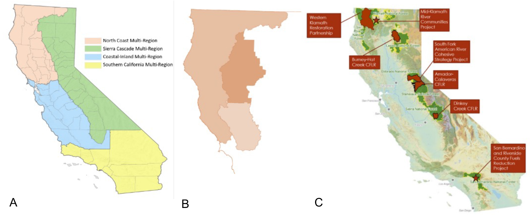
Western Klamath Restoration Partnership:
Much of the land that makes up the Klamath and Six Rivers national forests is the current and ancestral home to the Karuk Tribe. There is a pilot project under way to use fire to reshape damaged ecosystems. The tribe is part of the stakeholder group Western Klamath Restoration Partnership that has put together a detailed restoration plan using GIS to analyze and prioritize the restoration projects.
roadmap to 1m acres
Treatment Tracking Highlights:
The Task Force’s Monitoring, Reporting, and Assessment Work Group has completed Version 1.0 of the framework for the Forest & Wildland Stewardship Interagency Tracking System for all federal, state, local and tribal projects statewide. The Work Group will soon be contacting state and federal land agencies to begin data collection. The Task Force will provide an update of the system at the July meeting.
press box
May 31, 2022: Greenville was destroyed by wildfire. Can it be rebuilt to survive the next one?
May 24, 2022: Wildfire restoration efforts bring back native plants, wildlife
May 11, 2022: CapRadio Insight with Vicki Gonzalez (minute 9:45) – Director Patrick Wright; Craig Thomas, founder of The Fire Restoration Group; and attorney and partner Sara Clark at Shute, Mihaly & Weinberger, discuss California’s Strategic Plan for Expanding the Use of Beneficial Fire.
April 30, 2022: California’s giant sequoias are being destroyed by our wildfires. Scientists are resorting to extraordinary methods to save them
LEGISLATION WATCH
AB 1717 (Aguiar-Curry) Public works: definition. Expands the definition of public works to include fuels reduction work as part of wildfire mitigation projects and thus require the payment of prevailing wage for such projects.
AB 2251 (Calderon) Urban forestry: statewide strategic plan: statewide map. Requires CAL FIRE to develop a statewide strategic plan by 2025 to increase tree canopy coverage in urban areas by 10 percent by 2035.
AB 2649 (Garcia and Stone) Natural Carbon Sequestration and Resilience Act of 2022. Requires CNRA, on or before July 1, 2023, in coordination with its departments, including CARB and CDFA, to refine existing and establish new natural carbon sequestration pathways and strategies where appropriate.
AB 2878 (Aguiar-Curry) Forest Biomass Waste Utilization Program. Establishes the Forest Waste Biomass Utilization Program at the Joint Institute for Wood Products Innovation to develop an implementation plan to meet the goals of specified statewide forest management plans.
SB 926 (Dodd) Prescribed Fire Liability Pilot Program: Prescribed Fire Claims Fund. Requires CAL FIRE to establish the Prescribed Fire Liability Pilot Program, pursuant to SB 170 (Skinner), and to consult with the Department of General Services in establishing a Prescribed Fire Claims Fund.
SCIENCE HIGHLIGHTS
Knight et al., 2022: Land management explains major trends in forest structure and composition over the last millennium in California’s Klamath Mountains (fs.fed.us)
Liu et al., 2022: Inter-Basin Transfers Extend the Benefits of Water from Forests to Population Centers Across the Conterminous U.S.
Maxwell et al., 2022: Frequency of disturbance mitigates high-severity fire in the Lake Tahoe Basin, California and Nevada (fs.fed.us)
Stephens et al., 2022: Mass fire behavior created by extensive tree mortality and high tree density not predicted by operational fire behavior models in the southern Sierra Nevada
looking ahead
Wildland-Urban Interface Project:
OPR will soon release an inventory of best practices for planning, zooning, development review and code enforcement in the Wildlife Urban Interface (WUI). The inventory is called for under Key Action 2.5 of the Task Force’s Action Plan and will inform local governments on how best to develop and implement plans, codes, standards and enforcement activities within the WUI.
July Task Force Meeting:
The next meeting will be July 21 in Sacramento and will include an update on the interagency treatment tracking project and progress made to streamline regulatory processes for wildfire and forest resilience efforts.
SNC Approves More Than $21 Million In Wildfire Recovery and Forest Resilience Grants
SNC Approves More Than $21 Million In Wildfire Recovery and Forest Resilience Grants
The Sierra Nevada Conservancy (SNC) granted $21.8 million to 19 forest resilience and wildfire recovery projects at its recent June board meeting. Thirteen of the projects will take place on Forest Service and Bureau of Land Management lands, where federal land management agencies committed an additional $4.8 million to the forest resilience and wildfire recovery efforts. It’s important to note that many of these grants also build on collaborative planning and implementation efforts by state, federal, and local organizations that have been ongoing for years throughout the region.
Find more highlights about individual projects in an article on the SNC’s website, and more detail in SNC board materials starting on page 69 of the linked pdf.
RESOURCES
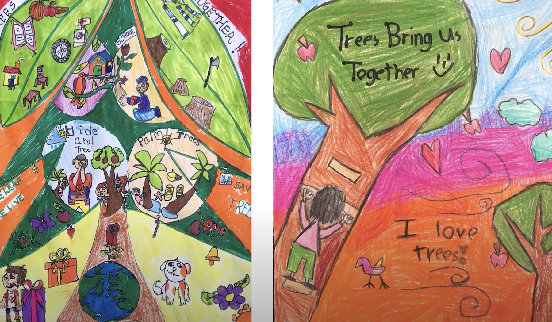
Arbor Week 2022 Poster Contest
Arbor Week 2022 Poster Contest
Jun 1, 2022: This year’s theme is Trees Bring Us Together. CAL FIRE thanks all the youth who submitted artwork for the 2022 annual Arbor Week Poster Contest, hosted by cooperating partner @calreleaf.
RESOURCES

CalVTP: Testing a New Tool for Forest Health Project Planning
CalVTP: Testing a New Tool for Forest Health Project Planning
In January 2020, CAL FIRE launched an effort known as CalVTP (California Vegetation Treatment Program) to reduce hazardous fuel conditions across California. Although CAL FIRE has primary responsibility for program implementation, the CalVTP Environmental Impact Report establishes processes that may also assist with California Environmental Quality Act (CEQA) compliance for fuel-reduction projects by other entities. In the Sierra Nevada, local organizations are learning what this new tool might mean for increasing the pace and scale of work to restore resilience to our forested landscapes.
RESOURCES
Welcome To The New Task Force Communications Platform
Welcome To The New Task Force Communications Platform
June 1, 2022 – A new visual identity, a monthly E-newsletter, social media and a beautiful, content-rich new website. It’s all part of a comprehensive communications platform for the Task Force that launched on June 1, 2022.
The Website
It all starts here, with the new website, built to deliver on two primary goals. First, to clearly articulate the purpose of the Task Force. For those unfamiliar or seeking to better understand, the Home Page and About section define the mission, structure, and initiatives of the Task Force.
Second, and no less important, is to show the progress being made by state, federal, local and tribal governments along with a wide range of other Task Force partners. The website is a a single hub for original content from the Task Force along with curated information sourced from partner agencies. It provides easy access to the very latest information that demonstrates tangible, boots on the ground progress on Task Force Goals and Key Action Areas.
You’ll find The Latest section on the Home Page, with an aggregation of the most recent progress and important stories. Below that, and also on the Progress Page, you can sort content by Task Force Goals and Action Areas.
We hope you’ll bookmark and come back to the site often. The news, information, and stories will be updated frequently.
The E-Newsletter
The first week of every month, the Task Force will send out an E-newsletter to all subscribers. Signing up for the E-newsletter is a great way to make sure you’re getting regular updates on the very latest progress. Look for the Sign-Up Form below on this page. When the E-newsletter comes, be sure to forward it on to others who may want to subscribe.
Social Media
The Task Force now has a presence on Facebook, Instagram, LinkedIn, and Twitter. We hope you’ll follow the Task Force social channels and engage with the content, then share Task Force social content on your social media and encourage others to follow. When appropriate, include the hashtag: #wildfiretaskforce.
“It’s all about showing progress,” according to Task Force Director Patrick Wright. “The new site is a one-stop-shop for the latest, boots-on-the-ground accomplishments, and we’re very pleased with how it came together.” Task Force Program Manager Kristen Merrill worked closely with the Communications Work Group and turned to Sonoma County creative communications agency The Idea Cooperative to develop the website, updated visual identity and online marketing materials.
Help Spread The Word
If you or your organization is involved in wildfire prevention, forest health and related fields, there is a role you can play in helping to let more people know about the critical work of the Task Force. The Partner Communications Kit page on the new site has tools and tips on how you can promote the Task Force in your communications. You’ll find instructions and downloadable digital assets for promoting the Task Force to your website audience, social media followers and email subscribers. Click below and start sharing today.
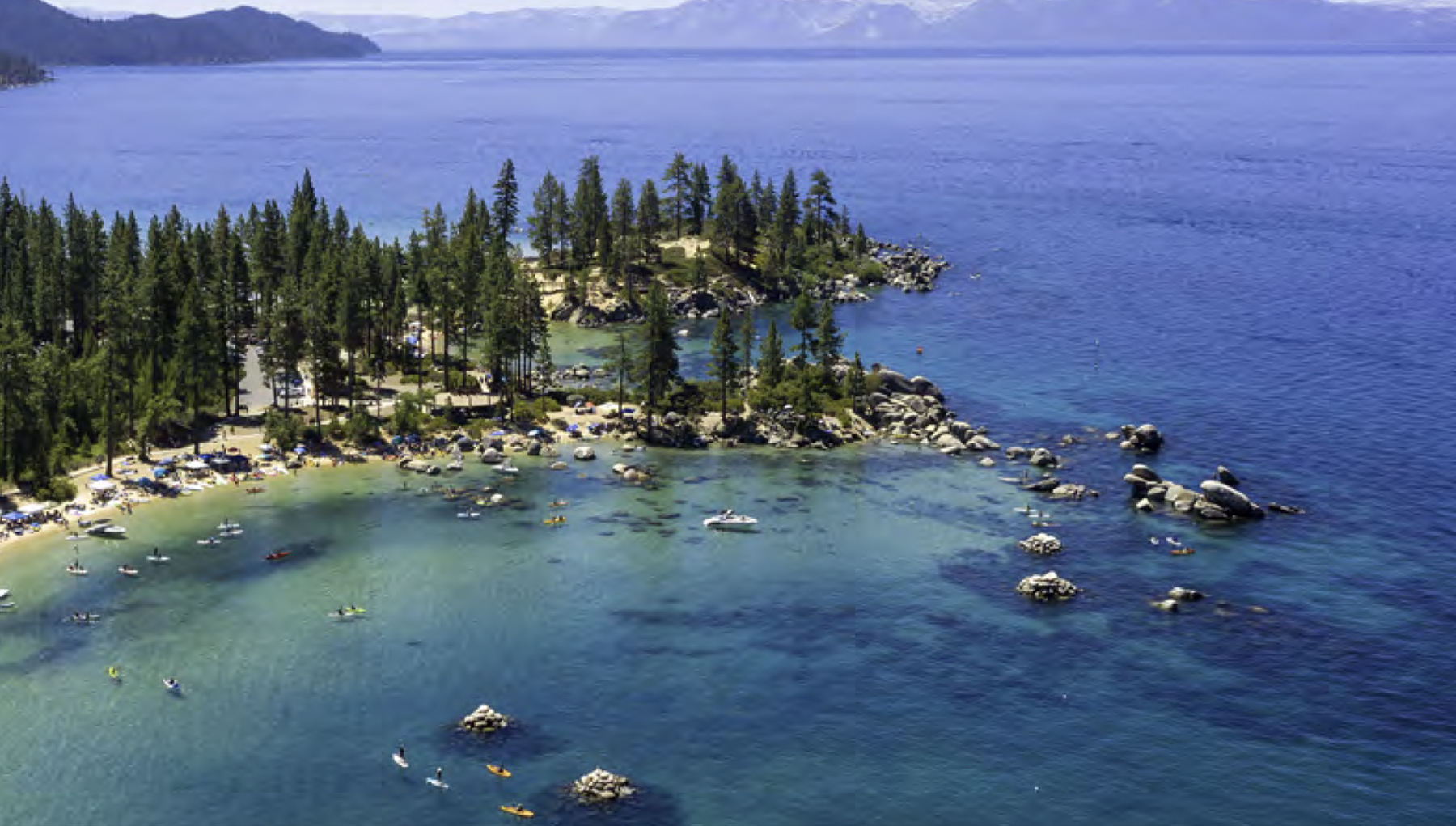
The Lake Tahoe Climate Resilience Action Strategy
The Lake Tahoe Climate Resilience Action Strategy
February 1, 2022: THE LAKE TAHOE CLIMATE RESILIENCE ACTION STRATEGY builds on existing Tahoe Basin climate and environmental improvement plans to identify five focus areas that will advance equity, create jobs, and build resilience for the
Basin’s extraordinary natural resources. One of the focus areas includes Reducing Wildfire Risk and Building Forest Resilience.
CONTACTS

Reimagining Big Basin Vision Summary
Reimagining Big Basin
State Parks is engaging stakeholders and the public in an effort to reimagine the future of Big Basin Redwoods State Park following the CZU Lightning Complex Fire that started on August 16, 2020.