
Southern California Regional Profile
Resilient & Fire-Safe Communities
Communities in the densely populated wildland-urban interface in Southern California face high risk of and serious consequences from wildfire. While management of public wildlands can increase resilience to wildfire and other disturbances, there is growing awareness that increasing community resilience to wildfire also requires proactive community planning, public education, and the active participation of Southern California’s diverse population.
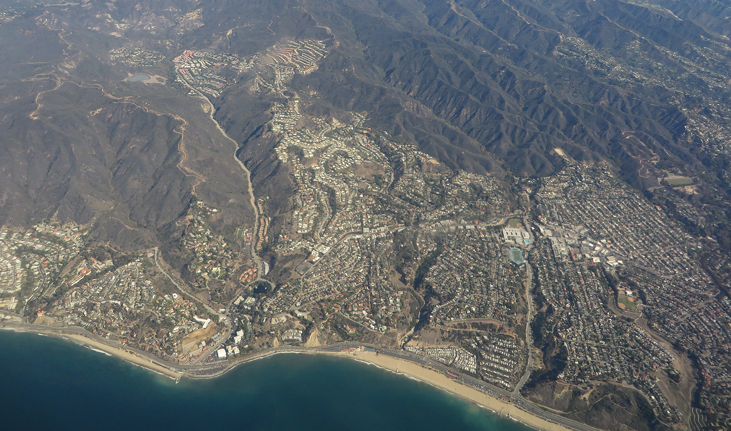
Many communities in Southern California are located within close proximity to large patches of natural lands; however, these developed areas typically have sparse or no wildland vegetation. In other parts of the state, houses and wildland vegetation directly intermingle in wildland urban interface communities. The separated but adjacent nature of urban development and wildland vegetation means fire is less likely to spread directly to homes from nearby wildland vegetation and is more likely to ignite from wind-carried embers, landscaping vegetation, or neighboring buildings. Consequently, measures that focus on modifying vegetation, such as fuel treatments, prescribed fire, and fuel breaks, are not sufficient to mitigate wildfire hazard.
Homeowners can increase the resilience of their homes via home hardening techniques, such as building and re-roofing with less flammable materials, screening vent openings, and enclosing eaves. Plants that are known to be highly flammable should be removed from close proximity to homes and replaced with properly distanced and well maintained fire-resistant species. Public engagement is needed to educate homeowners on the benefits of preparing homes for wildfire, recommended techniques, and available resources – such as those on CAL FIRE’s website.
Community vulnerability to wildfire is a function not only of exposure to wildfire hazard (e.g., proximity to a high fire risk area) but also sensitivity and adaptive capacity. Factors such as socioeconomic status, income, or age can limit individuals’ ability to afford fire mitigation services, such as home hardening techniques or vegetation treatments or have ready access to necessary information. They also might not be able to afford fire insurance or community firefighting resources, and have less capacity to rebuild or secure new housing after a disaster occurs. Many fire-prone areas are often characterized by higher income households because of the aesthetic value of wildland-urban interface areas, but this paradoxically means that low-income residents, or renters, within these same communities might be ineligible for financial resources and other types of assistance. Similarly, disadvantaged neighborhoods and other types of housing, such as trailer parks or apartment buildings, also can be found in these areas.
Other factors also contribute to individual and community vulnerability, including physical and cognitive disabilities, social or geographical isolation, and English-language proficiency. Emergency notifications, information on resources, and other critical announcements need to be translated and made accessible to diverse multilingual populations. Furthermore, the delivery should be tailored to how residents consume information. For example, low-income and technology-limited households may be better reached by direct mailings or print materials distributed at community centers, or, conversely, via different types of social media (e.g., Facebook, Instagram, or Whatsapp). Asking community-trusted representatives or intermediaries to share language-relevant information, and hosting public meetings in local areas can also be effective engagement strategies.
Recent catastrophic wildfires have also increased awareness of key vulnerabilities in the region. During the 2018 Woolsey Fire in Ventura and Los Angeles Counties, 250,000 people were evacuated. Most people evacuated via their own personal vehicles, which led to heavy congestion along primary evacuation routes, such as the Pacific Coast Highway. Local and regional planning can proactively consider how to address evacuation challenges related to traffic congestion, assisting vulnerable individuals who do not own vehicles or otherwise do not have the ability to evacuate. Additionally, these recent incidents have demonstrated a need for better equipping public shelters with essential resources, such as American with Disabilities Act accessible facilities, medical supplies, and trained staff.
Both public and private organizations have stepped up across the region to make Southern California communities more resilient and fire-safe. Fire Safe Councils help to engage private landowners, and some of these organizations have undertaken projects to protect high-risk areas and improve evacuation routes. Local Resource Conservation Districts, CAL FIRE, state conservancy agencies, and various nongovernmental organizations also support and lead community efforts to increase wildfire resilience. However, in all cases, capacity varies across the region, and more attention and resources are needed to ensure that vulnerable communities are protected.
Stakeholder Perspectives
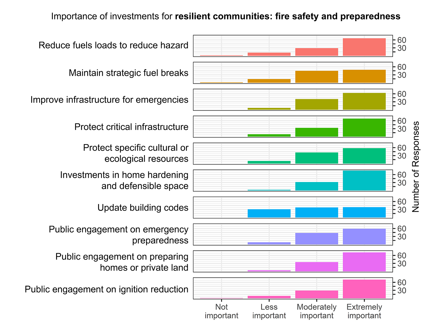
Survey respondents considered nearly all investments for increasing fire safety and preparedness as moderately to extremely important, with the exception of updating building codes. There was also less consensus on the importance of maintaining strategic fuel breaks and reducing fuels loads, compared to other areas of investment. Interviewees agreed that increasing community resilience to wildfire in Southern California requires the participation of wildland urban interface communities. Because vegetation treatments are less effective against wind driven fires, it is critical that homeowners implement home hardening and defensible space practices to protect their own house and other houses in their neighborhood. Interviewees observed that sometimes homeowners do not implement such recommended actions because they do not perceive it to be their responsibility or dislike the aesthetic impact. Additionally, interviewees highlighted that homeowner assistance resources and programs are not equitably available nor accessed across the region. Investments should be made to identify and prioritize communities that are not being reached by these programs.
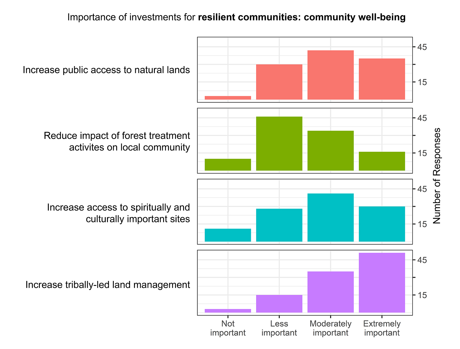
Survey respondents identified increasing tribally led land management as an extremely important investment for increasing social and cultural well-being; interviewees further stressed the importance of this investment. One interviewee noted that Southern California has the most diverse Tribes of anywhere in the continental United States, and there is enormous opportunity for Tribal involvement in wildfire resilience. Another interviewee noted opportunities for Tribes to lead management could be improved by providing more opportunities and support for cultural burning experts to receive the certifications the state or federal governments require.
Resource Conditions
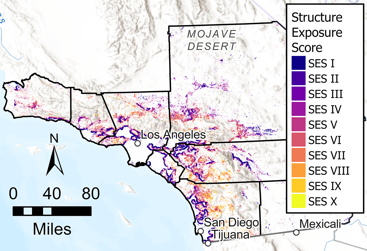
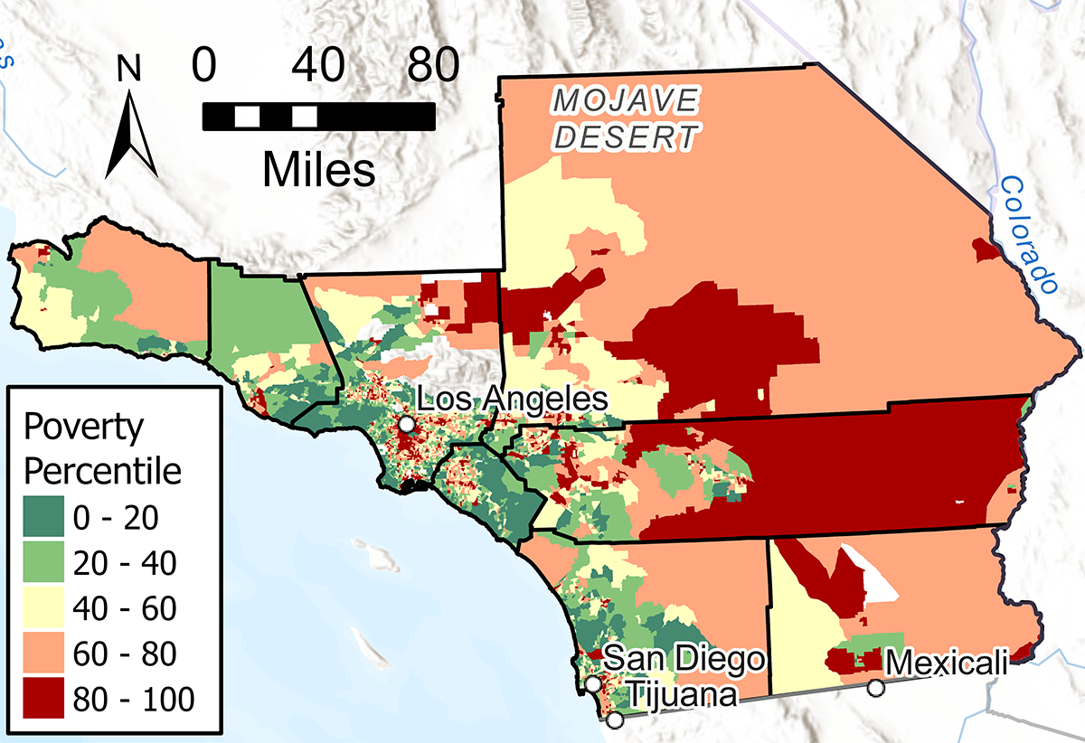
There are many metrics to assess community capacity and resiliency, including structure exposure score (A) and poverty percentile (B). Structure exposure score reflects the likelihood of a wildfire reaching the location, as well as the potential intensity and ember load of such a fire. Higher scores indicate a location with higher exposure and wildfire hazard. The regional resource kit assessed this score within wildland urban interface areas in the Southern California region. Poverty percentile is measured as percent of population living below two times the federal poverty level. Poverty percentile is considered to be a general metric of the socioeconomic well-being of a community and reflects community capacity to participate in measures that reduce the risk of wildfire hazard and to recover from disturbance. In the regional resource kit assessment of this metric, census tracts are represented by their percentile score in relation to other census tracts across California.